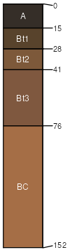
Libeg, extremely bouldery-Adel complex, 4 to 15 percent slopes
Libeg
(50%)
Upland Sagebrush Shrubland Group
Ustic Argicryolls
Well drained
Hydric: No
PAWS: 10 cm
mountains / Backslope
mountains / Footslope
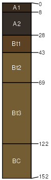
Adel
(35%)
Upland Alpine Group
Pachic Haplocryolls
Well drained
Hydric: No
PAWS: 26 cm
swales
mountains
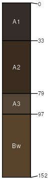
Millerlake
(5%)
Upland Grassland Group
Pachic Argicryolls
Well drained
Hydric: No
PAWS: 22 cm
fans
mountains
Monaberg
(5%)
Upland Grassland Group
Pachic Argicryolls
Well drained
Hydric: No
PAWS: 24 cm
mountains / Toeslope
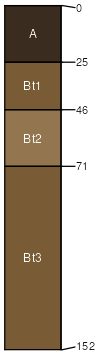
Redchief
(5%)
Upland Grassland Group
Ustic Argicryolls
Well drained
Hydric: No
PAWS: 13 cm
mountains / Backslope
mountains / Footslope
SSA
Scale
Published
Export
mt639
1:24,000
2000
2023-08-29