Fifer (45%)
Shallow Grassland Group
Ustic Haplocryolls
Well drained
Hydric: No
PAWS: 7 cm |
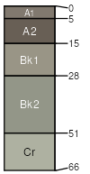
mountains / Summit mountains / Shoulder
|
|
Cheadle (40%)
Shallow Grassland Group
Lithic Haplocryolls
Well drained
Hydric: No
PAWS: 3 cm |
mountains / Summit mountains / Shoulder
|
|
Tongue River (4%)
Upland Cool Woodland Group
Eutric Haplocryalfs
Well drained
Hydric: No
PAWS: 15 cm |
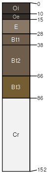
mountains / Backslope mountains / Footslope
|
|
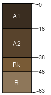
Knep (4%)
Upland Shrubland Group
Ustic Eutrocryepts
Well drained
Hydric: No
PAWS: 10 cm |
mountains / Backslope mountains / Footslope
|
|
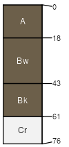
Fifer (4%)
Shallow Shrubland Group
Ustic Haplocryolls
Well drained
Hydric: No
PAWS: 6 cm |
mountains / Summit mountains / Shoulder
|
|
Rock outcrop (3%)
Hydric:
PAWS: NA |

|
|