Weedzunit-Ashbon complex, 15 to 45 percent slopes
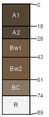
Weedzunit
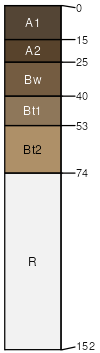
(50%)
Upland Sagebrush Shrubland Group
Typic Haplustolls
Well drained
Hydric: No
PAWS: 10 cm
hills / Backslope
hills / Footslope
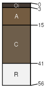
Ashbon
(40%)
Shallow Sagebrush Shrubland Group
Lithic Ustorthents
Well drained
Hydric: No
PAWS: 3 cm
hills / Summit
hills / Shoulder
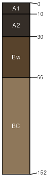
Breeton
(4%)
Sandy (Sy) RRU 46-S 15-19 PZ
Pachic Haplustolls
Well drained
Hydric: No
PAWS: 20 cm
hills / Footslope
hills / Toeslope
Shambo
(4%)
Silty (Si) RRU 46-S 13-19 PZ
Typic Haplustolls
Well drained
Hydric: No
PAWS: 28 cm
hills / Footslope
hills / Toeslope
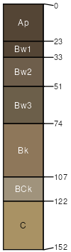
Pianohill
(2%)
Silty Steep (SiStp) RRU 46-C 13-19 PZ
Typic Argiustolls
Well drained
Hydric: No
PAWS: 13 cm
hills / Backslope
SSA
Scale
Published
Export
mt639
1:24,000
2000
2025-08-31