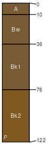
Whitesage-Rootel complex, 0 to 10 percent slopes
Whitesage
(45%)
Saline Lowland Drained Green River and Great Divide Basins (SLDr)
Aridic Calciustepts
Well drained
Hydric: No
PAWS: 29 cm
hills / Footslope
hills / Toeslope
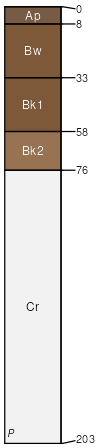
Rootel
(40%)
Loamy Foothills and Basins West (Ly)
Aridic Calciustepts
Well drained
Hydric: No
PAWS: 12 cm
hills / Shoulder
hills / Backslope
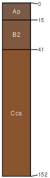
Glassner
(5%)
Ustertic Haplocambids
Hydric: No
PAWS: NA
Feltner
(5%)
Ustic Haplocalcids
Hydric: No
PAWS: NA
Brynie - draft
(5%)
Ustic Haplocalcids
Hydric: No
PAWS: NA
SSA
Scale
Published
Export
wy041
1:24,000
2025-09-04