Skaggs-Raynesford loams, 8 to 35 percent slopes
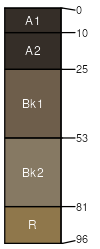
Skaggs
(50%)
Upland Grassland Group
Typic Calciborolls
Well drained
Hydric: No
PAWS: 12 cm
hills
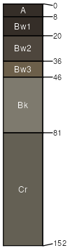
Raynesford
(30%)
Upland Grassland Group
Calcic Cryoborolls
Well drained
Hydric: No
PAWS: 21 cm
mountains
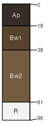
Skaggs
(10%)
Upland Shrubland Group
Calcic Cryoborolls
Well drained
Hydric: No
PAWS: 9 cm
hills
Castle
(5%)
Upland Shrubland Group
Udic Chromusterts
Well drained
Hydric: No
PAWS: 12 cm
hills
Teton
(5%)
Upland Shrubland Group
Typic Cryoborolls
Well drained
Hydric: No
PAWS: 15 cm
hills
SSA
Scale
Published
Export
mt602
1:20,000
1963
2025-08-30