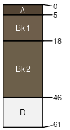
Rentsac-Kalsted complex, 8 to 25 percent slopes
Rentsac
(41%)
Shallow Sagebrush Shrubland Group
Lithic Calciustepts
Well drained
Hydric: No
PAWS: 4 cm
ridges
hills / Shoulder
hills / Backslope
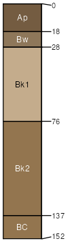
Kalsted
(39%)
Limy Sagebrush Shrubland Group
Aridic Calciustepts
Well drained
Hydric: No
PAWS: 16 cm
swales
hills / Footslope
Moderately deep soil
(7%)
Loamy (Lo) 10-14 PZ Frigid
Aridic Argiustolls
Well drained
Hydric: No
PAWS: 11 cm
hillsides
knolls
interfluves
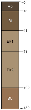
Varney
(7%)
Loamy Steep (LoStp) 10-14 PZ Frigid
Calcidic Argiustolls
Well drained
Hydric: No
PAWS: 19 cm
hills / Footslope
alluvial fans
Rock outcrop
(6%)
Hydric: No
PAWS: NA
SSA
Scale
Published
Export
mt636
1:24,000
1983
2025-08-31