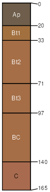
Nankin sandy clay loam, 6 to 10 percent slopes, eroded
Nankin
(90%)
Slopes, Loamy and Clayey, Moist
Typic Kanhapludults
Well drained
Hydric: No
PAWS: 22 cm
hills / Backslope
hills / Shoulder
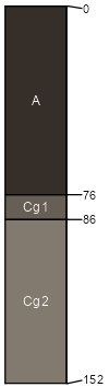
Johnston
(2%)
Small Stream Flood Plains, Wet
Cumulic Humaquepts
Very poorly drained
Hydric: Yes
PAWS: 13 cm
flood plains
SSA
Scale
Published
Export
sc069
1:24,000
1995
2025-09-02