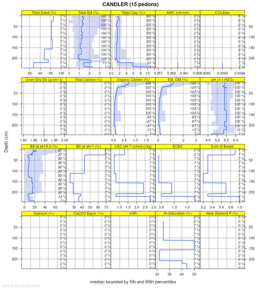
| Candler fine sand, 0 to 5 percent slopes | 2 | 24941 | 320681 | 2shkf | fl001 | 1982 | 1:15840 |
Candler fine sand, 5 to 8 percent slopes | 68 | 2209 | 320769 | 2v17j | fl001 | 1982 | 1:15840 |
Candler-Apopka complex, 0 to 5 percent slopes | 47 | 1754 | 320737 | brrc | fl001 | 1982 | 1:15840 |
Candler fine sand | 4 | 3724 | 1473290 | 1lg2h | fl009 | 1990 | 1:24000 |
Candler-Urban land complex | 5 | 1811 | 1473291 | 1lg2j | fl009 | 1990 | 1:24000 |
Candler fine sand, 0 to 5 percent slopes | 3 | 74078 | 321066 | 2shkf | fl017 | 1985 | 1:20000 |
Candler fine sand, 5 to 8 percent slopes | 4 | 6894 | 321076 | 2v17j | fl017 | 1985 | 1:20000 |
Candler-Urban land complex, 0 to 8 percent slopes | 32 | 1377 | 321069 | bs32 | fl017 | 1985 | 1:20000 |
Candler fine sand, 8 to 12 percent slopes | 41 | 154 | 321078 | bs3c | fl017 | 1985 | 1:20000 |
Candler fine sand, 0 to 5 percent slopes | 6 | 1610 | 1384385 | 1hgkl | fl049 | 1981 | 1:20000 |
Candler fine sand, 0 to 5 percent slopes | 14 | 90195 | 322076 | 2shkf | fl053 | 1976 | 1:20000 |
Candler fine sand, 5 to 8 percent slopes | 15 | 12786 | 322077 | 2v17j | fl053 | 1976 | 1:20000 |
Candler-Urban land complex | 16 | 1005 | 322078 | bt4m | fl053 | 1976 | 1:20000 |
Candler fine sand, 0 to 5 percent slopes | 7 | 28845 | 1407012 | 2shkf | fl057 | 1986 | 1:20000 |
Candler-Urban land complex, 0 to 5 percent slopes | 9 | 7400 | 1407014 | 1j73k | fl057 | 1986 | 1:20000 |
Candler fine sand, 5 to 12 percent slopes | 8 | 885 | 1407013 | 1j73j | fl057 | 1986 | 1:20000 |
Candler fine sand, 1 to 5 percent slopes | 6 | 60110 | 1414050 | 2ttl5 | fl075 | 1990 | 1:24000 |
Otela-Candler complex, 1 to 5 percent slopes | 12 | 38000 | 1414056 | 2y51j | fl075 | 1990 | 1:24000 |
Candler fine sand, 5 to 8 percent slopes | 77 | 10450 | 1414120 | 2v17j | fl075 | 1990 | 1:24000 |
Candler-Apopka complex, 1 to 5 percent slopes | 7 | 7200 | 1414051 | 1jgfk | fl075 | 1990 | 1:24000 |
Candler fine sand, 0 to 5 percent slopes | 4 | 28968 | 323154 | 2shkf | fl095 | 1986 | 1:20000 |
Candler fine sand, 5 to 12 percent slopes | 5 | 12769 | 323165 | bv8p | fl095 | 1986 | 1:20000 |
Candler-Urban land complex, 0 to 5 percent slopes | 7 | 7958 | 323173 | bv8y | fl095 | 1986 | 1:20000 |
Candler-Apopka fine sands, 5 to 12 percent slopes | 6 | 6921 | 323172 | bv8x | fl095 | 1986 | 1:20000 |
Candler-Urban land complex, 5 to 12 percent slopes | 8 | 1812 | 323174 | bv8z | fl095 | 1986 | 1:20000 |
Candler sand, 0 to 5 percent slopes | 7 | 6033 | 1483847 | 2t3z1 | fl097 | 1976 | 1:20000 |
Candler sand, 5 to 12 percent slopes | 8 | 2147 | 1483848 | 2w0q4 | fl097 | 1976 | 1:20000 |
Candler fine sand, 0 to 5 percent slopes | 13 | 29345 | 323181 | 2shkf | fl101 | 1980 | 1:20000 |
Candler fine sand, 5 to 8 percent slopes | 14 | 2030 | 323182 | 2v17j | fl101 | 1980 | 1:20000 |
Candler-Urban land complex, 0 to 8 percent slopes | 36 | 930 | 323205 | bv9z | fl101 | 1980 | 1:20000 |
Candler sand, 0 to 5 percent slopes | 3 | 97496 | 1424995 | 2t3z1 | fl105 | 1987 | 1:20000 |
Candler-Urban land complex, 0 to 5 percent slopes | 50 | 8070 | 1425039 | 1jtw0 | fl105 | 1987 | 1:20000 |
Candler sand, 5 to 8 percent slopes | 4 | 2809 | 1424996 | 1jttm | fl105 | 1987 | 1:20000 |
Candler fine sand, 0 to 5 percent slopes | 1 | 29650 | 323372 | 2shkf | fl107 | 1985 | 1:15840 |
Candler fine sand, 5 to 8 percent slopes | 2 | 8820 | 323383 | 2v17j | fl107 | 1985 | 1:15840 |
Candler-Urban land complex, 0 to 8 percent slopes | 54 | 960 | 323421 | bvjy | fl107 | 1985 | 1:15840 |
Candler sand, 12 to 25 percent slopes | 44 | 540 | 323410 | bvjl | fl107 | 1985 | 1:15840 |
Candler sand, 0 to 5 percent slopes | 4 | 20130 | 323647 | 2t3z1 | fl119 | 1985 | 1:24000 |
Candler sand, bouldery subsurface, 0 to 5 percent slopes | 65 | 2964 | 323675 | bvt4 | fl119 | 1985 | 1:24000 |
Candler sand, 5 to 8 percent slopes | 5 | 2199 | 323658 | bvsl | fl119 | 1985 | 1:24000 |
Candler sand, 8 to 12 percent slopes | 52 | 604 | 323661 | bvsp | fl119 | 1985 | 1:24000 |
Candler sand, 0 to 5 percent slopes | 8 | 73841 | 1603135 | 2t3z1 | fl607 | 1970 | 1:20000 |
Candler sand, 5 to 12 percent slopes | 9 | 37952 | 1603136 | 2w0q4 | fl607 | 1970 | 1:20000 |
Candler sand, 12 to 40 percent slopes | 10 | 4209 | 1542264 | 1nrvg | fl607 | 1970 | 1:20000 |
Candler sand, 0 to 5 percent slopes | 22 | 191809 | 1712905 | 2t3z1 | fl608 | 1979 | 1:15840 |
Candler sand, 5 to 12 percent slopes | 23 | 23493 | 1712906 | 2w0q4 | fl608 | 1979 | 1:15840 |
Candler clay, overwash, 0 to 2 percent slopes | 24 | 730 | 1712907 | 1vhf2 | fl608 | 1979 | 1:15840 |
Astatula and Candler sands, 0 to 5 percent slopes | 2 | 106364 | 2513613 | 2r3gx | fl609 | 1968 | 1:24000 |
Astatula and Candler sands, 5 to 12 percent slopes | 3 | 16143 | 2513614 | 2r8gs | fl609 | 1968 | 1:24000 |
Astatula and Candler sands, flora rich, 0 to 5 percent slopes | 13 | 7073 | 2727034 | 2r8h5 | fl609 | 1968 | 1:24000 |
Astatula and Candler sands, flora rich, 5 to 12 percent slopes | 14 | 1742 | 2727035 | 2r8h6 | fl609 | 1968 | 1:24000 |
Candler sand, 0 to 5 percent slopes | 19 | 1072 | 2822031 | 2t3z1 | fl609 | 1968 | 1:24000 |
Astatula and Candler sands, 12 to 20 percent slopes | 4 | 265 | 2513615 | 2r8gr | fl609 | 1968 | 1:24000 |

