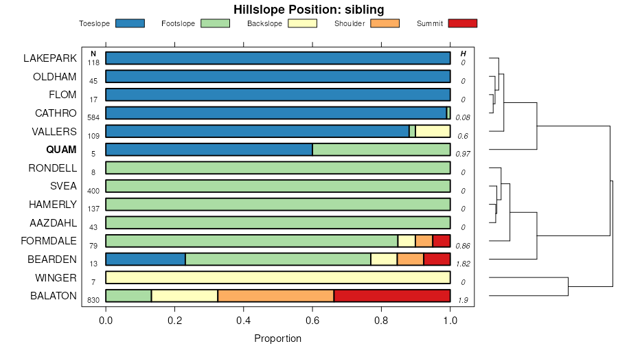
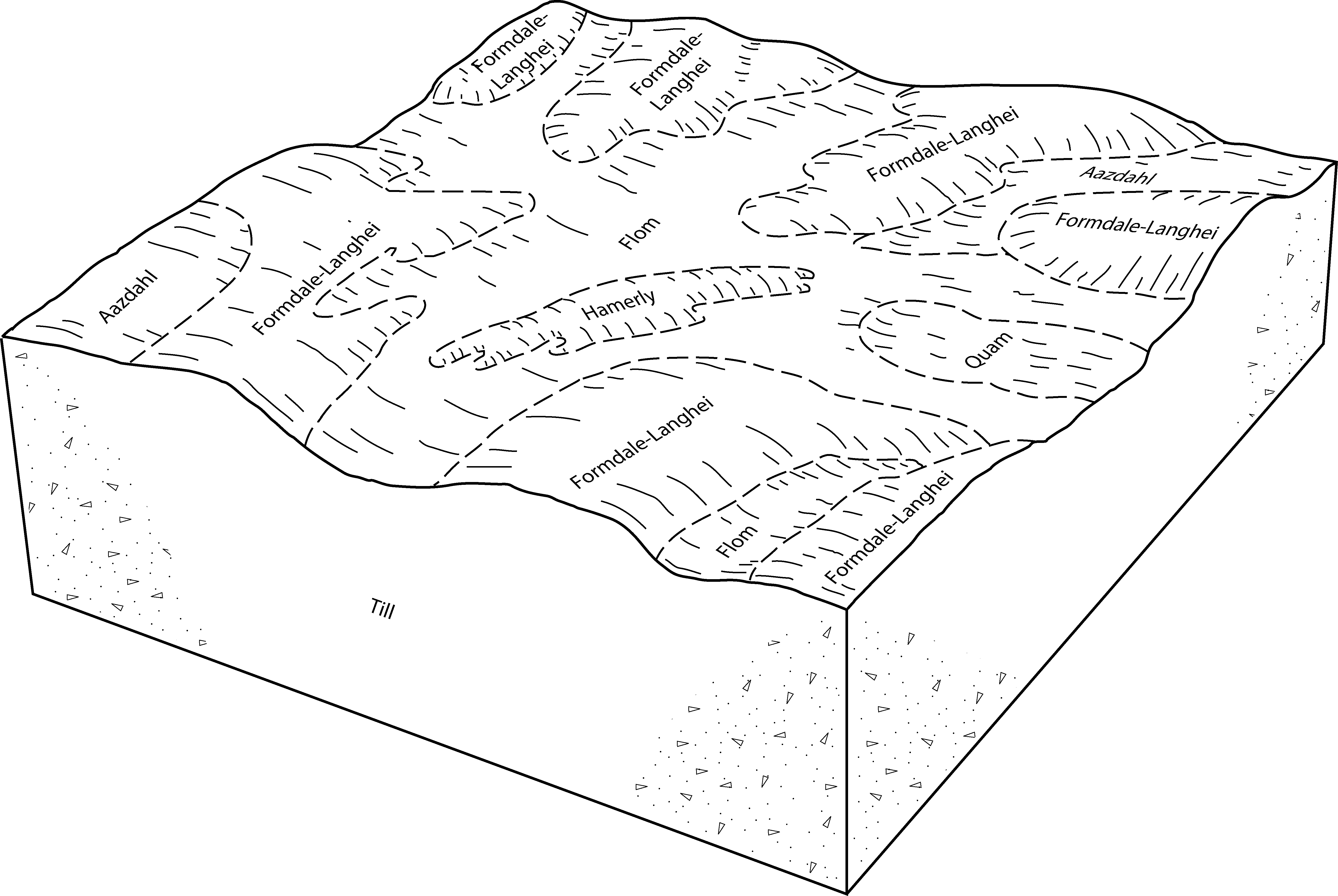
| Quam family, 0 to 5 percent slopes. | 172 | 9617 | 470393 | hsgz | ca702 | 1984 | 1:24000 |
Quam and Cathro soils, 0 to 1 percent slopes, frequently ponded | J130A | 8697 | 3182512 | 2yw5b | mn005 | 1994 | 1:20000 |
Quam-Cathro-Lakepark complex, 0 to2 percent slopes, frequently ponded | J132A | 4544 | 3182506 | 2yw53 | mn005 | 1994 | 1:20000 |
Quam, Cathro, and Urness soils, frequently ponded, 0 to 1 percent slopes | 1227 | 2782 | 397445 | 2w8fg | mn005 | 1994 | 1:20000 |
Quam silty clay loam, 0 to 1 percent slopes, occasionally ponded | J131A | 2704 | 3182505 | 2yw52 | mn005 | 1994 | 1:20000 |
Flom-Quam silty clay loams, 0 to 1 percent slopes, occasionally ponded | J116A | 1669 | 3182513 | 2yw5c | mn005 | 1994 | 1:20000 |
Aazdahl-Quam-Lakepark complex, 0 to 4 percent slopes | J112B | 1496 | 3182509 | 2yw57 | mn005 | 1994 | 1:20000 |
Quam silty clay loam, occasionally ponded, 0 to 1 percent slopes | 344 | 1157 | 397516 | 2vv68 | mn005 | 1994 | 1:20000 |
Flom-Aazdahl-Quam complex, 0 to 4 percent slopes | J114B | 362 | 3182511 | 2yw59 | mn005 | 1994 | 1:20000 |
Quam and Cathro soils, 0 to 1 percent slopes, frequently ponded | J130A | 11042 | 3182530 | 2yw5b | mn011 | 1990 | 1:20000 |
Quam silty clay loam, 0 to 1 percent slopes, occasionally ponded | J131A | 3740 | 3182523 | 2yw52 | mn011 | 1990 | 1:20000 |
Flom-Quam silty clay loams, 0 to 1 percent slopes, occasionally ponded | J116A | 1523 | 3182531 | 2yw5c | mn011 | 1990 | 1:20000 |
Flom-Aazdahl-Quam complex, 0 to 4 percent slopes | J114B | 560 | 3182529 | 2yw59 | mn011 | 1990 | 1:20000 |
Quam-Cathro-Lakepark complex, 0 to2 percent slopes, frequently ponded | J132A | 457 | 3182524 | 2yw53 | mn011 | 1990 | 1:20000 |
Aazdahl-Quam-Lakepark complex, 0 to 4 percent slopes | J112B | 336 | 3182527 | 2yw57 | mn011 | 1990 | 1:20000 |
Bearden-Quam, depressional, complex, 0 to 2 percent slopes | J51A | 88664 | 2423057 | 2mbd4 | mn023 | 1980 | 1:15840 |
Colvin-Quam complex, depressional, 0 to 1 percent slopes | J260A | 23937 | 2423070 | 2mbdk | mn023 | 1980 | 1:15840 |
Spicer-Quam silty clay loams | 1802 | 2828 | 396496 | f9l6 | mn023 | 1980 | 1:15840 |
Quam, Cathro, and Urness soils, frequently ponded, 0 to 1 percent slopes | J43A | 1189 | 3026449 | 2w8fg | mn023 | 1980 | 1:15840 |
Glyndon-Quam silty clay loams | 881 | 1118 | 396529 | f9m8 | mn023 | 1980 | 1:15840 |
Quam silty clay loam, occasionally ponded, 0 to 1 percent slopes | J17A | 1020 | 2423036 | 2vv68 | mn023 | 1980 | 1:15840 |
Quam, Cathro, and Urness soils, frequently ponded, 0 to 1 percent slopes | 1055 | 9113 | 356936 | 2w8fg | mn027 | 1980 | 1:20000 |
Quam silty clay loam, occasionally ponded, 0 to 1 percent slopes | 344 | 3161 | 356962 | 2vv68 | mn027 | 1980 | 1:20000 |
Quam silt loam | 344 | 2129 | 396842 | f9yc | mn037 | 1980 | 1:15840 |
Quam silt loam, ponded | 1824 | 866 | 396794 | f9wt | mn037 | 1980 | 1:15840 |
Quam silty clay loam, occasionally ponded, 0 to 1 percent slopes | Qu | 13451 | 397315 | 2vv68 | mn041 | 1970 | 1:12000 |
Quam, Cathro, and Urness soils, frequently ponded, 0 to 1 percent slopes | Mh | 7354 | 397296 | 2w8fg | mn041 | 1970 | 1:12000 |
Quam and Cathro soils, 0 to 1 percent slopes, frequently ponded | J130A | 12752 | 3182548 | 2yw5b | mn051 | 1974 | 1:20000 |
Quam silty clay loam, 0 to 1 percent slopes, occasionally ponded | J131A | 5614 | 3182541 | 2yw52 | mn051 | 1974 | 1:20000 |
Flom-Quam silty clay loams, 0 to 1 percent slopes, occasionally ponded | J116A | 4904 | 3182549 | 2yw5c | mn051 | 1974 | 1:20000 |
Quam-Cathro-Lakepark complex, 0 to2 percent slopes, frequently ponded | J132A | 3638 | 3182542 | 2yw53 | mn051 | 1974 | 1:20000 |
Quam, Cathro, and Urness soils, frequently ponded, 0 to 1 percent slopes | 1053 | 2936 | 398021 | 2w8fg | mn051 | 1974 | 1:20000 |
Aazdahl-Quam-Lakepark complex, 0 to 4 percent slopes | J112B | 1410 | 3182545 | 2yw57 | mn051 | 1974 | 1:20000 |
Quam silty clay loam, occasionally ponded, 0 to 1 percent slopes | 344 | 579 | 398041 | 2vv68 | mn051 | 1974 | 1:20000 |
Flom-Aazdahl-Quam complex, 0 to 4 percent slopes | J114B | 322 | 3182547 | 2yw59 | mn051 | 1974 | 1:20000 |
Quam mucky silty clay loam, depressional, MLRA 90, 0 to 1 percent slopes | C21A | 295 | 1673469 | 1t5cw | mn065 | 2006 | 1:12000 |
Quam, Cathro, and Urness soils, frequently ponded, 0 to 1 percent slopes | J43A | 7394 | 3026450 | 2w8fg | mn067 | 1983 | 1:20000 |
Quam silty clay loam, occasionally ponded, 0 to 1 percent slopes | J17A | 1105 | 2884431 | 2vv68 | mn067 | 1983 | 1:20000 |
Quam silty clay loam, occasionally ponded, 0 to 1 percent slopes | 344 | 4730 | 430300 | 2vv68 | mn073 | 1994 | 1:20000 |
Quam silty clay loam, depressional, 0 to 1 percent slopes | J17A | 1746 | 1149513 | 17l52 | mn081 | 2007 | 1:12000 |
Quam silty clay loam, depressional, 0 to 1 percent slopes | J17A | 4 | 1486219 | 1lwjk | mn083 | 2008 | 1:12000 |
Quam, Cathro, and Urness soils, frequently ponded, 0 to 1 percent slopes | 1804 | 7071 | 399212 | 2w8fg | mn087 | 1992 | 1:20000 |
Quam silty clay loam, occasionally ponded, 0 to 1 percent slopes | 344 | 858 | 399227 | 2vv68 | mn087 | 1992 | 1:20000 |
Quam mucky silty clay loam, depressional, MLRA 90, 0 to 1 percent slopes | C21A | 892 | 1676370 | 1t8dg | mn095 | 2006 | 1:12000 |
Quam silty clay loam, depressional, 0 to 1 percent slopes | J17A | 591 | 1149515 | 17l54 | mn101 | 2008 | 1:12000 |
Quam, Cathro, and Urness soils, frequently ponded, 0 to 1 percent slopes | Mh | 1074 | 357252 | 2w8fg | mn107 | 1970 | 1:20000 |
Quam, Cathro, and Urness soils, frequently ponded, 0 to 1 percent slopes | 1227 | 12570 | 435571 | 2w8fg | mn111 | 1996 | 1:20000 |
Quam and Cathro soils, 0 to 1 percent slopes, frequently ponded | J130A | 8093 | 3182566 | 2yw5b | mn111 | 1996 | 1:20000 |
Quam silty clay loam, occasionally ponded, 0 to 1 percent slopes | 1239 | 4937 | 435577 | 2vv68 | mn111 | 1996 | 1:20000 |
Flom-Quam silty clay loams, 0 to 1 percent slopes, occasionally ponded | J116A | 2935 | 3182567 | 2yw5c | mn111 | 1996 | 1:20000 |
Quam silty clay loam, 0 to 1 percent slopes, occasionally ponded | J131A | 2764 | 3182559 | 2yw52 | mn111 | 1996 | 1:20000 |
Quam-Cathro-Lakepark complex, 0 to2 percent slopes, frequently ponded | J132A | 2553 | 3182560 | 2yw53 | mn111 | 1996 | 1:20000 |
Aazdahl-Quam-Lakepark complex, 0 to 4 percent slopes | J112B | 2015 | 3182563 | 2yw57 | mn111 | 1996 | 1:20000 |
Flom-Aazdahl-Quam complex, 0 to 4 percent slopes | J114B | 660 | 3182565 | 2yw59 | mn111 | 1996 | 1:20000 |
Quam, Cathro, and Urness soils, frequently ponded, 0 to 1 percent slopes | 1055 | 1996 | 2947417 | 2w8fg | mn119 | 1996 | 1:20000 |
Quam, Cathro, and Urness soils, frequently ponded, 0 to 1 percent slopes | Mk | 5840 | 401371 | 2w8fg | mn121 | 1968 | 1:20000 |
Quam silty clay loam, occasionally ponded, 0 to 1 percent slopes | J17A | 3111 | 401350 | 2vv68 | mn121 | 1968 | 1:20000 |
Quam and Cathro soils, 0 to 1 percent slopes, frequently ponded | J130A | 431 | 3182584 | 2yw5b | mn121 | 1968 | 1:20000 |
Flom-Quam silty clay loams, 0 to 1 percent slopes, occasionally ponded | J116A | 173 | 3182585 | 2yw5c | mn121 | 1968 | 1:20000 |
Aazdahl-Quam-Lakepark complex, 0 to 4 percent slopes | J112B | 119 | 3182581 | 2yw57 | mn121 | 1968 | 1:20000 |
Quam silty clay loam, 0 to 1 percent slopes, occasionally ponded | J131A | 110 | 3182577 | 2yw52 | mn121 | 1968 | 1:20000 |
Quam-Cathro-Lakepark complex, 0 to2 percent slopes, frequently ponded | J132A | 94 | 3182578 | 2yw53 | mn121 | 1968 | 1:20000 |
Flom-Aazdahl-Quam complex, 0 to 4 percent slopes | J114B | 26 | 3182583 | 2yw59 | mn121 | 1968 | 1:20000 |
Quam silty clay loam, occasionally ponded, 0 to 1 percent slopes | 114 | 5158 | 428073 | 2vv68 | mn145 | 1980 | 1:15840 |
Quam, Cathro, and Urness soils, frequently ponded, 0 to 1 percent slopes | 1055 | 3300 | 428070 | 2w8fg | mn145 | 1980 | 1:15840 |
Quam and Cathro soils, 0 to 1 percent slopes, frequently ponded | J130A | 9700 | 3182602 | 2yw5b | mn149 | 1966 | 1:15840 |
Quam silty clay loam, 0 to 1 percent slopes, occasionally ponded | J131A | 6263 | 3182595 | 2yw52 | mn149 | 1966 | 1:15840 |
Flom-Quam silty clay loams, 0 to 1 percent slopes, occasionally ponded | J116A | 4422 | 3182603 | 2yw5c | mn149 | 1966 | 1:15840 |
Quam-Cathro-Lakepark complex, 0 to2 percent slopes, frequently ponded | J132A | 1656 | 3182596 | 2yw53 | mn149 | 1966 | 1:15840 |
Quam, Cathro, and Urness soils, frequently ponded, 0 to 1 percent slopes | Mh | 1093 | 428356 | 2w8fg | mn149 | 1966 | 1:15840 |
Aazdahl-Quam-Lakepark complex, 0 to 4 percent slopes | J112B | 927 | 3182599 | 2yw57 | mn149 | 1966 | 1:15840 |
Flom-Aazdahl-Quam complex, 0 to 4 percent slopes | J114B | 315 | 3182601 | 2yw59 | mn149 | 1966 | 1:15840 |
Bearden-Quam, depressional, complex, 0 to 2 percent slopes | J51A | 58936 | 434839 | glh2 | mn151 | 2000 | 1:12000 |
Quam silty clay loam, occasionally ponded, 0 to 1 percent slopes | J17A | 6328 | 434794 | 2vv68 | mn151 | 2000 | 1:12000 |
Quam, Cathro, and Urness soils, frequently ponded, 0 to 1 percent slopes | J43A | 4580 | 434828 | 2w8fg | mn151 | 2000 | 1:12000 |
Quam and Cathro soils, 0 to 1 percent slopes, frequently ponded | J130A | 5578 | 3182620 | 2yw5b | mn155 | 1986 | 1:20000 |
Flom-Quam silty clay loams, 0 to 1 percent slopes, occasionally ponded | J116A | 809 | 3182621 | 2yw5c | mn155 | 1986 | 1:20000 |
Quam silty clay loam, 0 to 1 percent slopes, occasionally ponded | J131A | 799 | 3182613 | 2yw52 | mn155 | 1986 | 1:20000 |
Quam-Cathro-Lakepark complex, 0 to2 percent slopes, frequently ponded | J132A | 765 | 3182614 | 2yw53 | mn155 | 1986 | 1:20000 |
Quam silty clay loam, ponded | 1940 | 404 | 357347 | czvb | mn155 | 1986 | 1:20000 |
Flom-Aazdahl-Quam complex, 0 to 4 percent slopes | J114B | 185 | 3182619 | 2yw59 | mn155 | 1986 | 1:20000 |
Quam silty clay loam, occasionally ponded, 0 to 1 percent slopes | 344 | 127 | 357359 | 2vv68 | mn155 | 1986 | 1:20000 |
Aazdahl-Quam-Lakepark complex, 0 to 4 percent slopes | J112B | 84 | 3182617 | 2yw57 | mn155 | 1986 | 1:20000 |
Quam, Cathro, and Urness soils, frequently ponded, 0 to 1 percent slopes | 1055 | 548 | 357390 | 2w8fg | mn167 | 1985 | 1:20000 |
Quam silty clay loam, occasionally ponded, 0 to 1 percent slopes | 344 | 255 | 357393 | 2vv68 | mn167 | 1985 | 1:20000 |
Quam silty clay loam, 0 to 1 percent slopes, occasionally ponded | J131A | 1 | 3182627 | 2yw52 | mn167 | 1985 | 1:20000 |


