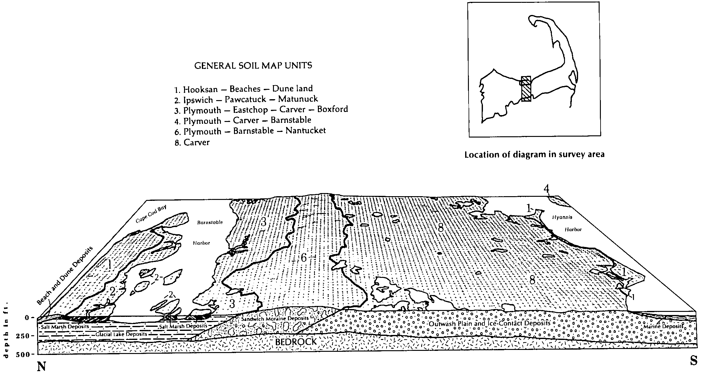
| Plymouth-Barnstable complex, hilly, extremely bouldery | 484D | 8388 | 276553 | 98s2 | ma001 | 1984 | 1:25000 |
Barnstable-Plymouth complex, rolling | 485C | 3910 | 276487 | 98py | ma001 | 1984 | 1:25000 |
Plymouth loamy coarse sand, 3 to 8 percent slopes | 435B | 3790 | 276544 | 2zggz | ma001 | 1984 | 1:25000 |
Barnstable-Plymouth-Nantucket complex, rolling, very bouldery | 494C | 3366 | 276491 | 98q2 | ma001 | 1984 | 1:25000 |
Plymouth-Barnstable complex, rolling, extremely bouldery | 484C | 3113 | 276552 | 98s1 | ma001 | 1984 | 1:25000 |
Plymouth-Barnstable complex, rolling, very bouldery | 483C | 2955 | 276550 | 98rz | ma001 | 1984 | 1:25000 |
Plymouth-Barnstable complex, hilly, very bouldery | 483D | 2670 | 276551 | 98s0 | ma001 | 1984 | 1:25000 |
Barnstable-Plymouth complex, rolling, very bouldery | 489C | 2619 | 276489 | 98q0 | ma001 | 1984 | 1:25000 |
Plymouth-Barnstable-Nantucket complex, hilly, very bouldery | 493D | 1960 | 276554 | 98s3 | ma001 | 1984 | 1:25000 |
Plymouth loamy coarse sand, 8 to 15 percent slopes | 435C | 1778 | 276545 | 2yldy | ma001 | 1984 | 1:25000 |
Barnstable-Plymouth complex, rolling, bouldery | 488C | 1585 | 276488 | 98pz | ma001 | 1984 | 1:25000 |
Plymouth loamy coarse sand, 15 to 35 percent slopes | 435D | 1532 | 276546 | 98rv | ma001 | 1984 | 1:25000 |
Plymouth loamy coarse sand, 3 to 8 percent slopes, very stony | 436B | 1489 | 276547 | 98rw | ma001 | 1984 | 1:25000 |
Barnstable-Plymouth-Nantucket complex, rolling | 490C | 845 | 276490 | 98q1 | ma001 | 1984 | 1:25000 |
Plymouth loamy coarse sand, 0 to 3 percent slopes | 435A | 619 | 276543 | 2zgh0 | ma001 | 1984 | 1:25000 |
Plymouth loamy coarse sand, 15 to 35 percent slopes, very stony | 436D | 522 | 276549 | 98ry | ma001 | 1984 | 1:25000 |
Plymouth loamy coarse sand, 8 to 15 percent slopes, very stony | 436C | 479 | 276548 | 98rx | ma001 | 1984 | 1:25000 |
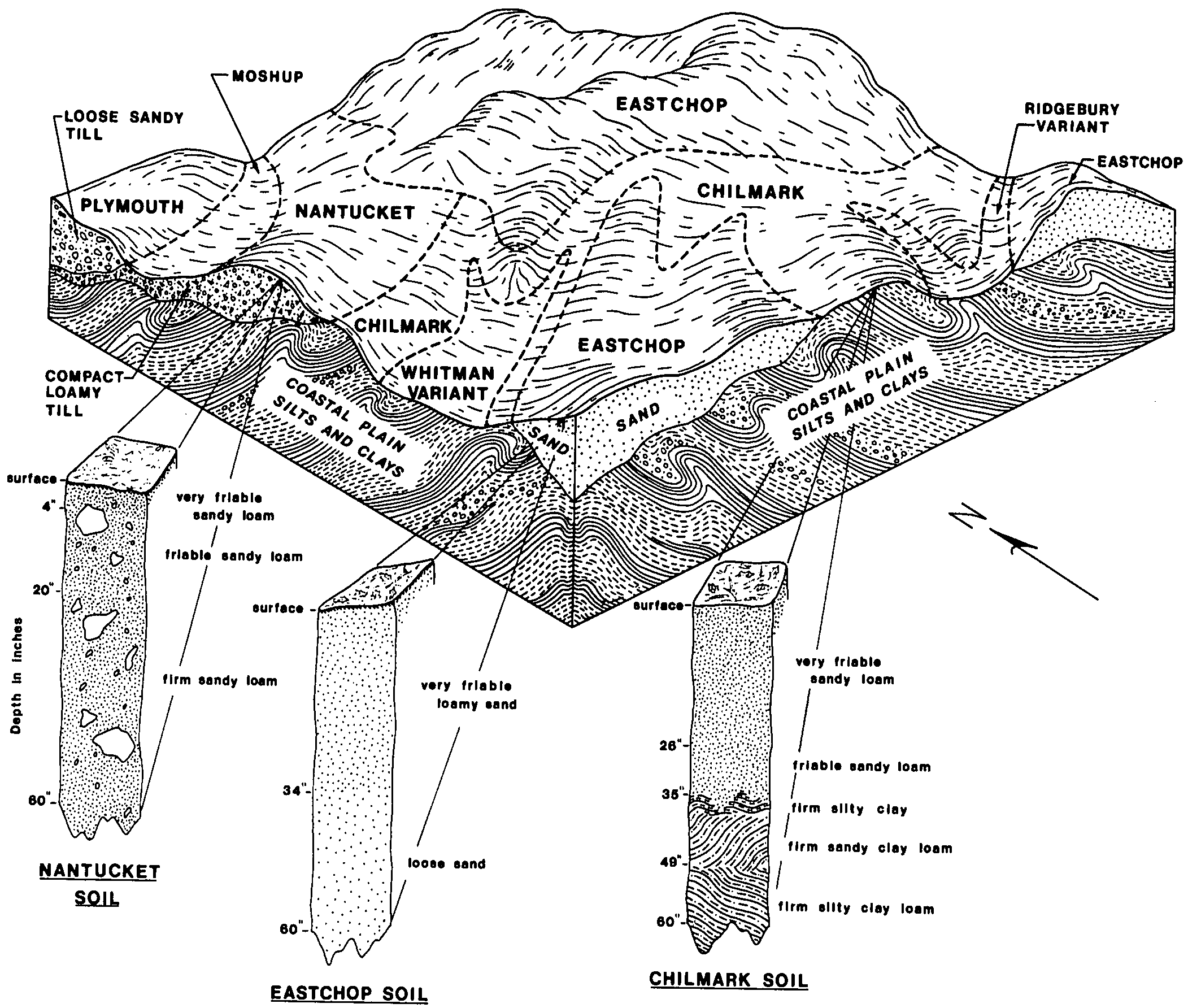
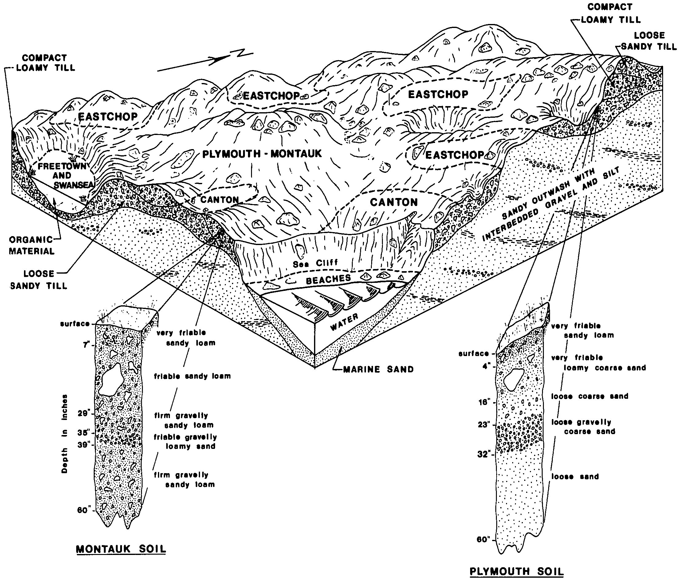
Plymouth-Montauk complex, 15 to 35 percent slopes, extremely bouldery | 475D | 2422 | 276702 | 2w806 | ma007 | 1983 | 1:20000 |
Nantucket-Plymouth complex, rolling, very stony | 498C | 988 | 276696 | 98xp | ma007 | 1983 | 1:20000 |
Plymouth-Montauk complex, 0 to 15 percent slopes, extremely bouldery | 475C | 939 | 276701 | 2w805 | ma007 | 1983 | 1:20000 |
Plymouth-Canton-Nantucket complex, rolling, very bouldery | 474C | 479 | 276700 | 98xt | ma007 | 1983 | 1:20000 |
Canton-Montauk-Plymouth complex, 0 to 15 percent slopes, extremely bouldery | 461C | 437 | 276663 | 2w801 | ma007 | 1983 | 1:20000 |
Plymouth-Nantucket complex, hilly, extremely bouldery | 476D | 297 | 276703 | 98xx | ma007 | 1983 | 1:20000 |
Nantucket-Plymouth complex, rolling | 497C | 263 | 276694 | 98xm | ma007 | 1983 | 1:20000 |
Nantucket-Plymouth complex, hilly, very stony | 498D | 243 | 276697 | 98xq | ma007 | 1983 | 1:20000 |
Nantucket-Plymouth complex, undulating, very stony | 498B | 98 | 276695 | 98xn | ma007 | 1983 | 1:20000 |
Canton-Montauk-Plymouth complex, 3 to 15 percent slopes | 460C | 65 | 276662 | 2w802 | ma007 | 1983 | 1:20000 |
Plymouth-Evesboro complex, 3 to 8 percent slopes | 479B | 2352 | 276991 | 9976 | ma019 | 1977 | 1:20000 |
Plymouth-Evesboro complex, 8 to 15 percent slopes | 479C | 1872 | 276992 | 9977 | ma019 | 1977 | 1:20000 |
Plymouth-Evesboro complex, 15 to 25 percent slopes | 479D | 1106 | 276993 | 9978 | ma019 | 1977 | 1:20000 |
Plymouth - Carver complex, 8 to 15 percent slopes | 480C | 5321 | 309409 | bcyy | ma023 | 2010 | 1:12000 |
Plymouth - Carver complex, 15 to 35 percent slopes | 480E | 4054 | 309408 | bcyx | ma023 | 2010 | 1:12000 |
Plymouth - Carver complex, 3 to 8 percent slopes | 480B | 2945 | 309410 | bcyz | ma023 | 2010 | 1:12000 |
Plymouth - Carver complex, 8 to 15 percent slopes, bouldery | 481C | 2601 | 309412 | bcz1 | ma023 | 2010 | 1:12000 |
Plymouth loamy coarse sand, 15 to 35 percent slopes, extremely bouldery | 438E | 2340 | 309405 | bcyt | ma023 | 2010 | 1:12000 |
Plymouth loamy coarse sand, 8 to 15 percent slopes | 435C | 1947 | 309399 | 2yldy | ma023 | 2010 | 1:12000 |
Plymouth loamy coarse sand, 8 to 15 percent slopes, bouldery | 437C | 1941 | 309403 | bcyr | ma023 | 2010 | 1:12000 |
Plymouth loamy coarse sand, 15 to 35 percent slopes, bouldery | 437E | 1925 | 309402 | bcyq | ma023 | 2010 | 1:12000 |
Plymouth - Carver complex, 3 to 8 percent slopes, bouldery | 481B | 1415 | 309413 | bcz2 | ma023 | 2010 | 1:12000 |
Plymouth loamy coarse sand, 3 to 8 percent slopes | 435B | 1337 | 309400 | 2zggz | ma023 | 2010 | 1:12000 |
Plymouth loamy coarse sand, 3 to 8 percent slopes, bouldery | 437B | 1243 | 309404 | bcys | ma023 | 2010 | 1:12000 |
Plymouth loamy coarse sand, 8 to 15 percent slopes, extremely bouldery | 438C | 1212 | 309406 | bcyv | ma023 | 2010 | 1:12000 |
Plymouth loamy coarse sand, 15 to 35 percent slopes | 435E | 1177 | 309398 | bcyl | ma023 | 2010 | 1:12000 |
Plymouth - Carver complex, 15 to 35 percent slopes, bouldery | 481E | 1160 | 309411 | bcz0 | ma023 | 2010 | 1:12000 |
Plymouth - Poquonock complex, 3 to 8 percent slopes, bouldery | 478B | 842 | 599851 | n461 | ma023 | 2010 | 1:12000 |
Barnstable - Plymouth complex, 8 to 15 percent slopes | 486C | 649 | 309508 | bd24 | ma023 | 2010 | 1:12000 |
Barnstable - Plymouth complex, 3 to 8 percent slopes | 486B | 560 | 309505 | bd21 | ma023 | 2010 | 1:12000 |
Barnstable - Plymouth complex, 8 to 15 percent slopes, very bouldery | 483C | 529 | 309509 | bd25 | ma023 | 2010 | 1:12000 |
Barnstable - Plymouth complex, 15 to 35 percent slopes, very bouldery | 483E | 506 | 319840 | bqtf | ma023 | 2010 | 1:12000 |
Plymouth loamy coarse sand, 0 to 3 percent slopes | 435A | 401 | 309401 | 2zgh0 | ma023 | 2010 | 1:12000 |
Plymouth loamy coarse sand, 3 to 8 percent slopes, extremely bouldery | 438B | 336 | 309407 | bcyw | ma023 | 2010 | 1:12000 |
Plymouth - Poquonock complex, 8 to 15 percent slopes, bouldery | 478C | 276 | 309419 | bcz8 | ma023 | 2010 | 1:12000 |
Barnstable - Plymouth complex, 15 to 35 percent slopes | 486E | 247 | 309507 | bd23 | ma023 | 2010 | 1:12000 |
Plymouth - Poquonock complex, 15 to 35 percent slopes, bouldery | 478E | 126 | 2441808 | 2myx0 | ma023 | 2010 | 1:12000 |
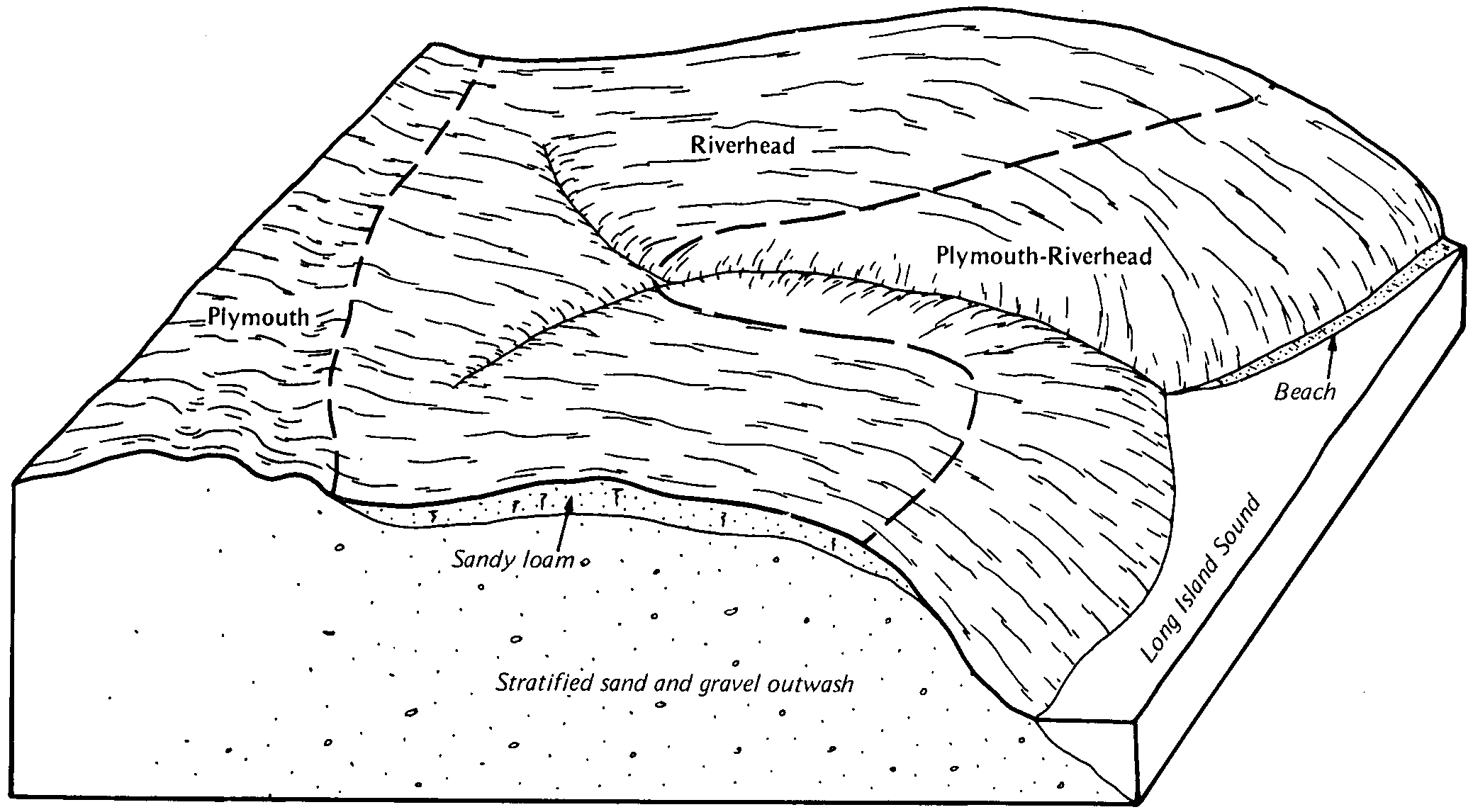
Plymouth-Riverhead complex, 15 to 35 percent slopes | PrD | 3348 | 292926 | 9tt7 | ny059 | 1983 | 1:24000 |
Urban land-Plymouth complex, 3 to 8 percent slopes | UpB | 1005 | 292946 | 9ttw | ny059 | 1983 | 1:24000 |
Plymouth loamy coarse sand, 3 to 8 percent slopes | PlB | 841 | 292924 | 2zggz | ny059 | 1983 | 1:24000 |
Urban land-Plymouth complex, 0 to 3 percent slopes | UpA | 820 | 292945 | 9ttv | ny059 | 1983 | 1:24000 |
Plymouth loamy coarse sand, 8 to 15 percent slopes | PlC | 656 | 292925 | 2yldy | ny059 | 1983 | 1:24000 |
Urban land-Plymouth complex, 15 to 25 percent slopes | UpD | 408 | 292948 | 9tty | ny059 | 1983 | 1:24000 |
Urban land-Plymouth complex, 8 to 15 percent slopes | UpC | 398 | 292947 | 9ttx | ny059 | 1983 | 1:24000 |
Carver and Plymouth soils, 3 to 15 percent slopes | CpC | 43006 | 295228 | 2zggw | ny103 | 1970 | 1:20000 |
Plymouth loamy coarse sand, 0 to 3 percent slopes | PlA | 38899 | 295257 | 2zgh0 | ny103 | 1970 | 1:20000 |
Carver and Plymouth soils, 15 to 35 percent slopes | CpE | 33766 | 295229 | 2zggy | ny103 | 1970 | 1:20000 |
Plymouth loamy coarse sand, 3 to 8 percent slopes | PlB | 26569 | 295258 | 2zggz | ny103 | 1970 | 1:20000 |
Carver and Plymouth soils, 0 to 3 percent slopes | CpA | 25123 | 295227 | 2zggv | ny103 | 1970 | 1:20000 |
Plymouth loamy coarse sand, 8 to 15 percent slopes | PlC | 12811 | 295259 | 2yldy | ny103 | 1970 | 1:20000 |
Plymouth loamy sand, silty substratum, 0 to 3 percent slopes | PsA | 1838 | 295262 | 9x7l | ny103 | 1970 | 1:20000 |
Plymouth gravelly loamy sand, 8 to 15 percent slopes, eroded | PmC3 | 1145 | 295261 | 9x7k | ny103 | 1970 | 1:20000 |
Plymouth gravelly loamy sand, 3 to 8 percent slopes, eroded | PmB3 | 869 | 295260 | 9x7j | ny103 | 1970 | 1:20000 |
Plymouth loamy sand, silty substratum, 3 to 8 percent slopes | PsB | 866 | 295263 | 9x7m | ny103 | 1970 | 1:20000 |
Riverhead and Plymouth very bouldery soils, 15 to 35 percent slopes | RpE | 562 | 295273 | 9x7y | ny103 | 1970 | 1:20000 |


