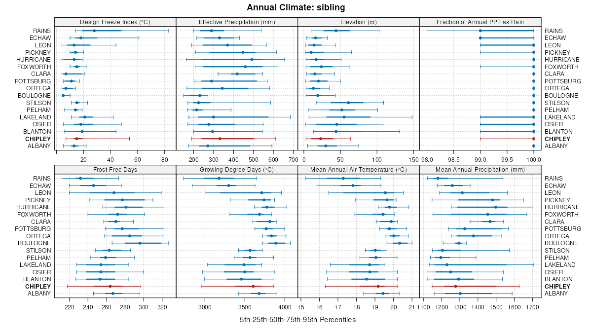
Official Series Description


Lab Data Summary

Aggregate lab data for the CHIPLEY soil series. This aggregation is based on all pedons with a current taxon name of CHIPLEY, and applied along 1-cm thick depth slices. Solid lines are the slice-wise median, bounded on either side by the interval defined by the slice-wise 5th and 95th percentiles. The median is the value that splits the data in half. Five percent of the data are less than the 5th percentile, and five percent of the data are greater than the 95th percentile. Values along the right hand side y-axis describe the proportion of pedon data that contribute to aggregate values at this depth. For example, a value of "90%" at 25cm means that 90% of the pedons correlated to CHIPLEY were used in the calculation. Source: KSSL snapshot . Methods used to assemble the KSSL snapshot used by SoilWeb / SDE

Click the image to view it full size.

Pedons used in the lab summary:

MLRALab IDPedon IDTaxonnameCINSSL / NASIS ReportsLink To SoilWeb GMap
133AS37_0131976-FL073-S37_013Chipley3Primary | Supplementary | Taxonomy | Pedon | Water Retention | Correlation | Andic Soil Properties30.4689388,-84.0639038
133AS66_0211979-FL131-S66_021Chipley3Primary | Supplementary | Taxonomy | Pedon | Water Retention | Correlation | Andic Soil Properties30.7271004,-86.3279953
133AS03_0181981-FL005-S03_018Chipley3Primary | Supplementary | Taxonomy | Pedon | Water Retention | Correlation | Andic Soil Properties30.395628,-85.4257813
133AS24_0061986-FL047-S24_006Chipley3Primary | Supplementary | Taxonomy | Pedon | Water Retention | Correlation | Andic Soil Properties30.5705605,-83.1622162
133AS46_0131986-FL091-S46_013Chipley3Primary | Supplementary | Taxonomy | Pedon | Water Retention | Correlation | Andic Soil Properties30.6787224,-86.5880051
133AS07_0111988-FL013-S07_011Chipley3Primary | Supplementary | Taxonomy | Pedon | Water Retention | Correlation | Andic Soil Properties30.421669,-85.3066711
133AS39_0041989-FL077-S39_004Chipleyn/aPrimary | Supplementary | Taxonomy | Pedon | Water Retention | Correlation | Andic Soil Properties30.4583302,-84.9077835
133AS17_004YYYY-FL033-S17_004Chipleyn/aPrimary | Supplementary | Taxonomy | Pedon | Water Retention | Correlation | Andic Soil Properties30.976572,-87.2465057
152AS40_0231985-FL079-S40_023Chipley3Primary | Supplementary | Taxonomy | Pedon | Water Retention | Correlation | Andic Soil Properties30.3282948,-83.6867218
152AS19_0081986-FL037-S19_008Chipley3Primary | Supplementary | Taxonomy | Pedon | Water Retention | Correlation | Andic Soil Properties29.9328537,-84.5110016
152AS38_0191986-FL075-S38_019Chipley3Primary | Supplementary | Taxonomy | Pedon | Water Retention | Correlation | Andic Soil Properties29.4313526,-82.6427689
152AS65_0181986-FL129-S65_018Chipley3Primary | Supplementary | Taxonomy | Pedon | Water Retention | Correlation | Andic Soil Properties30.0259857,-84.4370575
152AS62_0091988-FL123-S62_009Chipley3Primary | Supplementary | Taxonomy | Pedon | Water Retention | Correlation | Andic Soil Properties29.9011116,-83.4080582
152AS23_0101989-FL045-S23_010Chipley3Primary | Supplementary | Taxonomy | Pedon | Water Retention | Correlation | Andic Soil Properties29.7604218,-85.2582169
153BS45_0041984-FL089-S45_004Chipley3Primary | Supplementary | Taxonomy | Pedon | Water Retention | Correlation | Andic Soil Properties30.6151333,-81.5435486
155S01_0681976-FL001-S01_068Chipley3Primary | Supplementary | Taxonomy | Pedon | Water Retention | Correlation | Andic Soil Properties29.7302666,-82.4187012
155S55_0141978-FL109-S55_014Chipley3Primary | Supplementary | Taxonomy | Pedon | Water Retention | Correlation | Andic Soil Properties29.6674919,-81.2949295

Water Balance

Monthly water balance estimated using a leaky-bucket style model for the CHIPLEY soil series. Monthly precipitation (PPT) and potential evapotranspiration (PET) have been estimated from the 50th percentile of gridded values (PRISM 1981-2010) overlapping with the extent of SSURGO map units containing each series as a major component. Monthly PET values were estimated using the method of Thornthwaite (1948). These (and other) climatic parameters are calculated with each SSURGO refresh and provided by the fetchOSD function of the soilDB package. Representative water storage values (“AWC” in the figures) were derived from SSURGO by taking the 50th percentile of profile-total water storage (sum[awc_r * horizon thickness]) for each soil series. Note that this representation of “water storage” is based on the average ability of most plants to extract soil water between 15 bar (“permanent wilting point”) and 1/3 bar (“field capacity”) matric potential. Soil moisture state can be roughly interpreted as “dry” when storage is depleted, “moist” when storage is between 0mm and AWC, and “wet” when there is a surplus. Clearly there are a lot of assumptions baked into this kind of monthly water balance. This is still a work in progress.

Click the image to view it full size.


Click the image to view it full size.

Sibling Summary

Siblings are those soil series that occur together in map units, in this case with the CHIPLEY series. Sketches are arranged according to their subgroup-level taxonomic structure. Source: SSURGO snapshot , parsed OSD records and snapshot of SC database .

Click the image to view it full size.

Select annual climate data summaries for the CHIPLEY series and siblings. Series are sorted according to hierarchical clustering of median values. Source: SSURGO map unit geometry and 1981-2010, 800m PRISM data .

Click the image to view it full size.

Geomorphic description summaries for the CHIPLEY series and siblings. Series are sorted according to hierarchical clustering of proportions and relative hydrologic position within an idealized landform (e.g. top to bottom). Most soil series (SSURGO components) are associated with a hillslope position and one or more landform-specific positions: hills, mountain slopes, terraces, and/or flats. Proportions can be interpreted as an aggregate representation of geomorphic membership. The values printed to the left (number of component records) and right (Shannon entropy) of stacked bars can be used to judge the reliability of trends. Small Shannon entropy values suggest relatively consistent geomorphic association, while larger values suggest lack thereof. Source: SSURGO component records .

Click the image to view it full size.

Click the image to view it full size.

There are insufficient data to create the 3D mountains figure.

Click the image to view it full size.

Click the image to view it full size.

Competing Series

Soil series competing with CHIPLEY share the same family level classification in Soil Taxonomy. Source: parsed OSD records and snapshot of the SC database .

Click the image to view it full size.

Select annual climate data summaries for the CHIPLEY series and competing. Series are sorted according to hierarchical clustering of median values. Source: SSURGO map unit geometry and 1981-2010, 800m PRISM data .

Click the image to view it full size.

Geomorphic description summaries for the CHIPLEY series and competing. Series are sorted according to hierarchical clustering of proportions and relative hydrologic position within an idealized landform (e.g. top to bottom). Proportions can be interpreted as an aggregate representation of geomorphic membership. Most soil series (SSURGO components) are associated with a hillslope position and one or more landform-specific positions: hills, mountain slopes, terraces, and/or flats. The values printed to the left (number of component records) and right (Shannon entropy) of stacked bars can be used to judge the reliability of trends. Shannon entropy values close to 0 represent soil series with relatively consistent geomorphic association, while values close to 1 suggest lack thereof. Source: SSURGO component records .

Click the image to view it full size.

Click the image to view it full size.

There are insufficient data to create the 3D mountains figure.

Click the image to view it full size.

There are insufficient data to create the 3D flats position figure.

Soil series sharing subgroup-level classification with CHIPLEY, arranged according to family differentiae. Hovering over a series name will print full classification and a small sketch from the OSD. Source: snapshot of SC database .

Block Diagrams

No block diagrams are available.

Map Units

Map units containing CHIPLEY as a major component. Limited to 250 records.

Map Unit Name Symbol Map Unit Area (ac) Map Unit Key National Map Unit Symbol Soil Survey Area Publication Date Map Scale
Chipley sand2814823320694brpzfl00119821:15840
Chipley sand, 0 to 5 percent slopes23127223208112ttksfl00519821:20000
Chipley sand, 5 to 8 percent slopes242693208122w4g6fl00519821:20000
Chipley fine sand, 0 to 5 percent slopes22864631634p689fl00719881:15840
Chipley sand, 0 to 5 percent slopes12582614809932ttksfl01319971:20000
Chipley fine sand, 0 to 5 percent slopes206720797440vrswfl02319811:24000
Albany-Ocilla-Chipley complex, 0 to 5 percent slopes101422514218171jqj2fl03920061:12000
Foxworth-Blanton-Chipley complex, 0 to 5 percent slopes93336514080961j87gfl03920061:12000
Hurricane and Chipley soils, 0 to 3 percent slopes79273313816181hcpbfl03920061:12000
Chipley-Foxworth complex, 0 to 5 percent slopes82225513816211hcpffl03920061:12000
Chipley, Leon, and Foxworth soils, 0 to 5 percent slopes78181313816171hcp9fl03920061:12000
Leon-Chipley complex33146913815731hcmwfl03920061:12000
Bonifay-Leon-Chipley complex, 0 to 5 percent slopes8535813816241hcpjfl03920061:12000
Chipley sand, 0 to 5 percent slopes86720114886817kh8fl04719951:24000
Chipley sand741701017240134j6fl05919711:12000
Chipley fine sand, 0 to 5 percent slopes32190700466rhwpfl06519841:20000
Chipley fine sand, 0 to 2 percent slopes81212014544671kth9fl07319891:20000
Chipley-Foxworth complex, 0 to 5 percent slopes118460322697btslfl07720041:24000
Hurricane and Chipley soils, 0 to 3 percent slopes314380322719btt9fl07720041:24000
Leon-Chipley complex98516727851t4ntfl07720041:24000
Chipley fine sand, 0 to 5 percent slopes28292013803131hbb7fl07919881:15840
Chipley and Hurricane soils, 0 to 5 percent slopes41009014446861kh9sfl09119891:20000
Hurricane, Albany, and Chipley soils, 0 to 3 percent slopes266473102334013bvzfl12120031:24000
Chipley-Foxworth-Albany complex, 0 to 5 percent slopes452386102335913bwlfl12120031:24000
Boulogne-Chipley-Hurricane complex, 0 to 5 percent slopes731903102338713bxhfl12120031:24000
Chipley-Lynn Haven, depressional-Boulogne complex, 0 to 3 percent slopes14647014252081jv1gfl12319981:24000
Chipley sand, 0 to 5 percent slopes73172514252751jv3mfl12319981:24000
Chipley fine sand, 0 to 5 percent slopes2279014145871jgzvfl12519891:15840
Chipley sand, 0 to 5 percent slopes4116103240102ttksfl13119851:20000
Chipley sand, 5 to 8 percent slopes58203240212w4g6fl13119851:20000
Chipley-Albany-Hurricane complex, 0 to 5 percent slopes551051023984742lht4fl13320091:12000
Albany, Chipley, Leon complex, 0 to 5 percent slopes9484023984622lhsrfl13320091:12000
Leon-Chipley complex10047423984912lhtpfl13320091:12000
Chipley sand, 0 to 2 percent slopesCmA6090324520bwpdga03119651:20000
Chipley sand, 0 to 2 percent slopesChA1064324570bwr0ga03319821:20000
Chipley sand, 0 to 2 percent slopesChA221517010931v33zga10320071:24000
Albany and Chipley soils, 0 to 3 percent slopesAHA6570324746bwxpga10719931:20000
Chipley fine sand, 0 to 2 percent slopesBgA9203247902zd2gga16519661:20000
Chipley sand, 0 to 2 percent slopesChA6380324836bx0lga18519751:20000
Chipley sand, 0 to 2 percent slopesCmA916012491645zkga22919651:20000
Chipley sand, 0 to 2 percent slopesChA164525803632qbf3ga25120111:24000
Chipley fine sand, frequently floodedCmA277012533946f6ga60919671:20000
Chipley sandCh4940325418bxmcga61219751:20000
Chipley fine sandCm1912512537146g7ga61319691:20000
Chipley-Urban land complexCuc684512537346g9ga61319691:20000
Albany-Chipley complex, 0 to 5 percent slopesAcB384626868002rz9pga62620131:24000
Chipley soils, frequently floodedCy2945325550bxrmga62719701:20000
Chipley sand, 0 to 2 percent slopesCmA747325827by1kga63819871:20000
Chipley sand, 0 to 4 percent slopesCh526012579846x0ga64419801:20000
Chipley sandCh15231143173tynnc14719691:15840
Chipley sand, 0 to 2 percent slopesChA133061150443vq3nc16319821:24000
Seabrook fine sandSk240401324364ft4sc01319751:20000
Chipley-Echaw complexCt238001319504f9gsc01519741:20000
Chipley fine sand, 0 to 2 percent slopes21116381322634fmksc02919801:20000
Chipley sand, 0 to 2 percent slopesCpA35101297404c05sc03319761:20000
Chipley sand, 0 to 2 percent slopesChA80001297914c1tsc03519851:20000
Chipley loamy sand, dark surfaceCn40941299474c6vsc04119691:20000
Chipley fine sand, 0 to 2 percent slopes54A20170639592pgk0sc04319801:20000
Chipley fine sand, 0 to 2 percent slopesChA35121300974ccpsc04919901:20000
Chipley-Pelham-Echaw associationCK100701325384fxfsc05319751:20000
Chipley fine sand, 0 to 2 percent slopesChA57121325414fxjsc05319751:20000
Seabrook fine sandSk15291325804fyssc05319751:20000
Chipley sand, 0 to 2 percent slopesClA66491315094dv7sc08919851:20000
Chipley sand424651193274058va09319821:15840
Leon-Chipley sands8790119332405fva09319821:15840
Chipley-Leon complex, 0 to 2 percent slopes9A104812248943g8va18119971:24000
Chipley fine sand, 0 to 4 percent slopes8B80912248843g7va18119971:24000
Chipley-Leon complex, 2 to 5 percent slopes9B69912249243gcva18119971:24000

Map of Series Extent

Approximate geographic distribution of the CHIPLEY soil series. To learn more about how this distribution was mapped, or to compare this soil series extent to others, use the Series Extent Explorer (SEE) application. Source: generalization of SSURGO geometry .