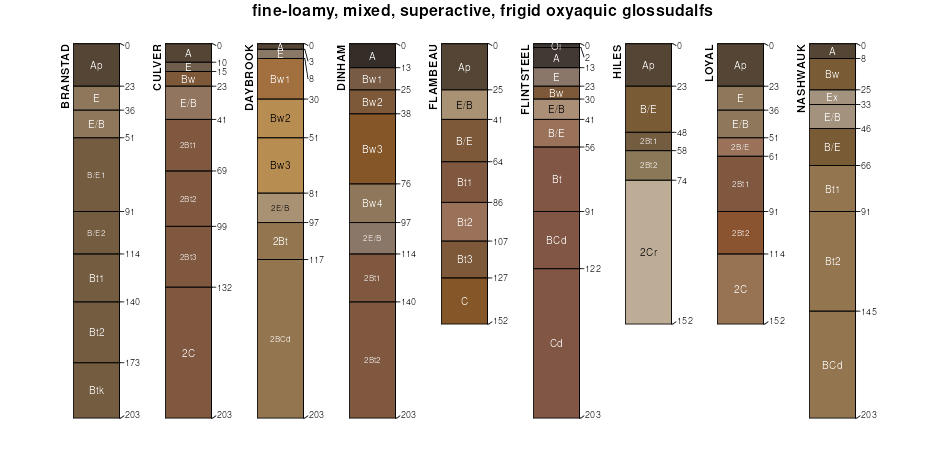
Official Series Description


Lab Data Summary

Aggregate lab data for the BRANSTAD soil series. This aggregation is based on all pedons with a current taxon name of BRANSTAD, and applied along 1-cm thick depth slices. Solid lines are the slice-wise median, bounded on either side by the interval defined by the slice-wise 5th and 95th percentiles. The median is the value that splits the data in half. Five percent of the data are less than the 5th percentile, and five percent of the data are greater than the 95th percentile. Values along the right hand side y-axis describe the proportion of pedon data that contribute to aggregate values at this depth. For example, a value of "90%" at 25cm means that 90% of the pedons correlated to BRANSTAD were used in the calculation. Source: KSSL snapshot . Methods used to assemble the KSSL snapshot used by SoilWeb / SDE

Click the image to view it full size.

Pedons used in the lab summary:

MLRALab IDPedon IDTaxonnameCINSSL / NASIS ReportsLink To SoilWeb GMap
90B40A162875WI095002Branstad7Primary | Supplementary | Taxonomy | Pedon | Water Retention | Correlation | Andic Soil Properties45.5836029,-92.6710281
90B93P0460S1992WI013003Branstad6Primary | Supplementary | Taxonomy | Pedon | Water Retention | Correlation | Andic Soil Properties45.773056,-92.6872253
90B94P0365S1993WI013001BRANSTAD6Primary | Supplementary | Taxonomy | Pedon | Water Retention | Correlation | Andic Soil Properties45.7455559,-92.6997223

Water Balance

Monthly water balance estimated using a leaky-bucket style model for the BRANSTAD soil series. Monthly precipitation (PPT) and potential evapotranspiration (PET) have been estimated from the 50th percentile of gridded values (PRISM 1981-2010) overlapping with the extent of SSURGO map units containing each series as a major component. Monthly PET values were estimated using the method of Thornthwaite (1948). These (and other) climatic parameters are calculated with each SSURGO refresh and provided by the fetchOSD function of the soilDB package. Representative water storage values (“AWC” in the figures) were derived from SSURGO by taking the 50th percentile of profile-total water storage (sum[awc_r * horizon thickness]) for each soil series. Note that this representation of “water storage” is based on the average ability of most plants to extract soil water between 15 bar (“permanent wilting point”) and 1/3 bar (“field capacity”) matric potential. Soil moisture state can be roughly interpreted as “dry” when storage is depleted, “moist” when storage is between 0mm and AWC, and “wet” when there is a surplus. Clearly there are a lot of assumptions baked into this kind of monthly water balance. This is still a work in progress.

Click the image to view it full size.


Click the image to view it full size.

Sibling Summary

Siblings are those soil series that occur together in map units, in this case with the BRANSTAD series. Sketches are arranged according to their subgroup-level taxonomic structure. Source: SSURGO snapshot , parsed OSD records and snapshot of SC database .

Click the image to view it full size.

Select annual climate data summaries for the BRANSTAD series and siblings. Series are sorted according to hierarchical clustering of median values. Source: SSURGO map unit geometry and 1981-2010, 800m PRISM data .

Click the image to view it full size.

Geomorphic description summaries for the BRANSTAD series and siblings. Series are sorted according to hierarchical clustering of proportions and relative hydrologic position within an idealized landform (e.g. top to bottom). Most soil series (SSURGO components) are associated with a hillslope position and one or more landform-specific positions: hills, mountain slopes, terraces, and/or flats. Proportions can be interpreted as an aggregate representation of geomorphic membership. The values printed to the left (number of component records) and right (Shannon entropy) of stacked bars can be used to judge the reliability of trends. Small Shannon entropy values suggest relatively consistent geomorphic association, while larger values suggest lack thereof. Source: SSURGO component records .

Click the image to view it full size.

Click the image to view it full size.

There are insufficient data to create the 3D mountains figure.

There are insufficient data to create the 3D terrace figure.

Click the image to view it full size.

Competing Series

Soil series competing with BRANSTAD share the same family level classification in Soil Taxonomy. Source: parsed OSD records and snapshot of the SC database .

Click the image to view it full size.

Select annual climate data summaries for the BRANSTAD series and competing. Series are sorted according to hierarchical clustering of median values. Source: SSURGO map unit geometry and 1981-2010, 800m PRISM data .

Click the image to view it full size.

Geomorphic description summaries for the BRANSTAD series and competing. Series are sorted according to hierarchical clustering of proportions and relative hydrologic position within an idealized landform (e.g. top to bottom). Proportions can be interpreted as an aggregate representation of geomorphic membership. Most soil series (SSURGO components) are associated with a hillslope position and one or more landform-specific positions: hills, mountain slopes, terraces, and/or flats. The values printed to the left (number of component records) and right (Shannon entropy) of stacked bars can be used to judge the reliability of trends. Shannon entropy values close to 0 represent soil series with relatively consistent geomorphic association, while values close to 1 suggest lack thereof. Source: SSURGO component records .

Click the image to view it full size.

Click the image to view it full size.

There are insufficient data to create the 3D mountains figure.

There are insufficient data to create the 3D terrace figure.

There are insufficient data to create the 3D flats position figure.

Soil series sharing subgroup-level classification with BRANSTAD, arranged according to family differentiae. Hovering over a series name will print full classification and a small sketch from the OSD. Source: snapshot of SC database .

Block Diagrams

No block diagrams are available.

Map Units

Map units containing BRANSTAD as a major component. Limited to 250 records.

Map Unit Name Symbol Map Unit Area (ac) Map Unit Key National Map Unit Symbol Soil Survey Area Publication Date Map Scale
Branstad loam, 2 to 6 percent slopes204B17225432881gjfxmn00119961:20000
Branstad loam, 2 to 6 percent slopesC18B247843247917307clmn02519901:15840
Alstad-Branstad loams, 0 to 4 percent slopesC80B202703247923307cgmn02519901:15840
Cushing, moderately eroded-Branstad loams, 2 to 15 percent slopesC82C189523247925307crmn02519901:15840
Cushing-Branstad complex, 6 to 35 percent slopes, moderately erodedC82D185343247926307csmn02519901:15840
Branstad-Cushing, moderately eroded, loams, 2 to 15 percent slopesC18C10493247924307cmmn02519901:15840
Branstad-Alstad-Talmoon loams, 0 to 4 percent slopesC84B8053247928307cpmn02519901:15840
Cushing, moderately eroded-Branstad loams, 2 to 15 percent slopesC82C180763247939307crmn05919561:20000
Branstad loam, 2 to 6 percent slopesC18B159843247931307clmn05919561:20000
Alstad-Branstad loams, 0 to 4 percent slopesC80B66623247937307cgmn05919561:20000
Cushing-Branstad complex, 6 to 35 percent slopes, moderately erodedC82D16483247940307csmn05919561:20000
Branstad-Alstad-Talmoon loams, 0 to 4 percent slopesC84B8323247942307cpmn05919561:20000
Branstad-Cushing, moderately eroded, loams, 2 to 15 percent slopesC18C7163247938307cmmn05919561:20000
Branstad loam, 2 to 6 percent slopesC18B616734641t5cqmn06520061:12000
Cushing, moderately eroded-Branstad loams, 2 to 15 percent slopesC82C3633247955307crmn09520061:12000
Branstad loam, 2 to 6 percent slopesC18B1953247947307clmn09520061:12000
Cushing-Branstad complex, 6 to 35 percent slopes, moderately erodedC82D1873247956307csmn09520061:12000
Alstad-Branstad loams, 0 to 4 percent slopesC80B793247953307cgmn09520061:12000
Branstad-Alstad-Talmoon loams, 0 to 4 percent slopesC84B73247958307cpmn09520061:12000
Branstad-Cushing, moderately eroded, loams, 2 to 15 percent slopesC18C73247954307cmmn09520061:12000
Alstad-Branstad loams, 0 to 4 percent slopesC80B131353247966307cgmn11520091:24000
Branstad loam, 2 to 6 percent slopesC18B113063247960307clmn11520091:24000
Cushing, moderately eroded-Branstad loams, 2 to 15 percent slopesC82C52113247968307crmn11520091:24000
Cushing-Branstad complex, 6 to 35 percent slopes, moderately erodedC82D15773247969307csmn11520091:24000
Branstad-Cushing, moderately eroded, loams, 2 to 15 percent slopesC18C1253247967307cmmn11520091:24000
Branstad-Alstad-Talmoon loams, 0 to 4 percent slopesC84B963247971307cpmn11520091:24000
Cushing-Branstad complex, 6 to 35 percent slopes, moderately erodedC82D23123247982307csmn16319781:15840
Cushing, moderately eroded-Branstad loams, 2 to 15 percent slopesC82C3033247981307crmn16319781:15840
Branstad loam, 2 to 6 percent slopesC18B2013247973307clmn16319781:15840
Branstad-Alstad-Talmoon loams, 0 to 4 percent slopesC84B343247984307cpmn16319781:15840
Branstad-Cushing, moderately eroded, loams, 2 to 15 percent slopesC18C313247980307cmmn16319781:15840
Alstad-Branstad loams, 0 to 4 percent slopesC80B183247979307cgmn16319781:15840
Branstad loam, 2 to 6 percent slopesC18B53863247987307clwi01320041:12000
Alstad-Branstad loams, 0 to 4 percent slopesC80B24253247993307cgwi01320041:12000
Branstad-Cushing, moderately eroded, loams, 2 to 15 percent slopesC18C23873247994307cmwi01320041:12000
Cushing-Branstad complex, 6 to 35 percent slopes, moderately erodedC82D23813247996307cswi01320041:12000
Branstad-Alstad-Talmoon loams, 0 to 4 percent slopesC84B18023247998307cpwi01320041:12000
Cushing, moderately eroded-Branstad loams, 2 to 15 percent slopesC82C7123247995307crwi01320041:12000
Cushing-Branstad complex, 6 to 35 percent slopes, moderately erodedC82D67673248009307cswi09519781:15840
Cushing, moderately eroded-Branstad loams, 2 to 15 percent slopesC82C46373248008307crwi09519781:15840
Branstad loam, 2 to 6 percent slopesC18B40373248000307clwi09519781:15840
Alstad-Branstad loams, 0 to 4 percent slopesC80B6953248006307cgwi09519781:15840
Branstad-Cushing, moderately eroded, loams, 2 to 15 percent slopesC18C3473248007307cmwi09519781:15840
Branstad-Alstad-Talmoon loams, 0 to 4 percent slopesC84B2553248011307cpwi09519781:15840

Map of Series Extent

Approximate geographic distribution of the BRANSTAD soil series. To learn more about how this distribution was mapped, or to compare this soil series extent to others, use the Series Extent Explorer (SEE) application. Source: generalization of SSURGO geometry .