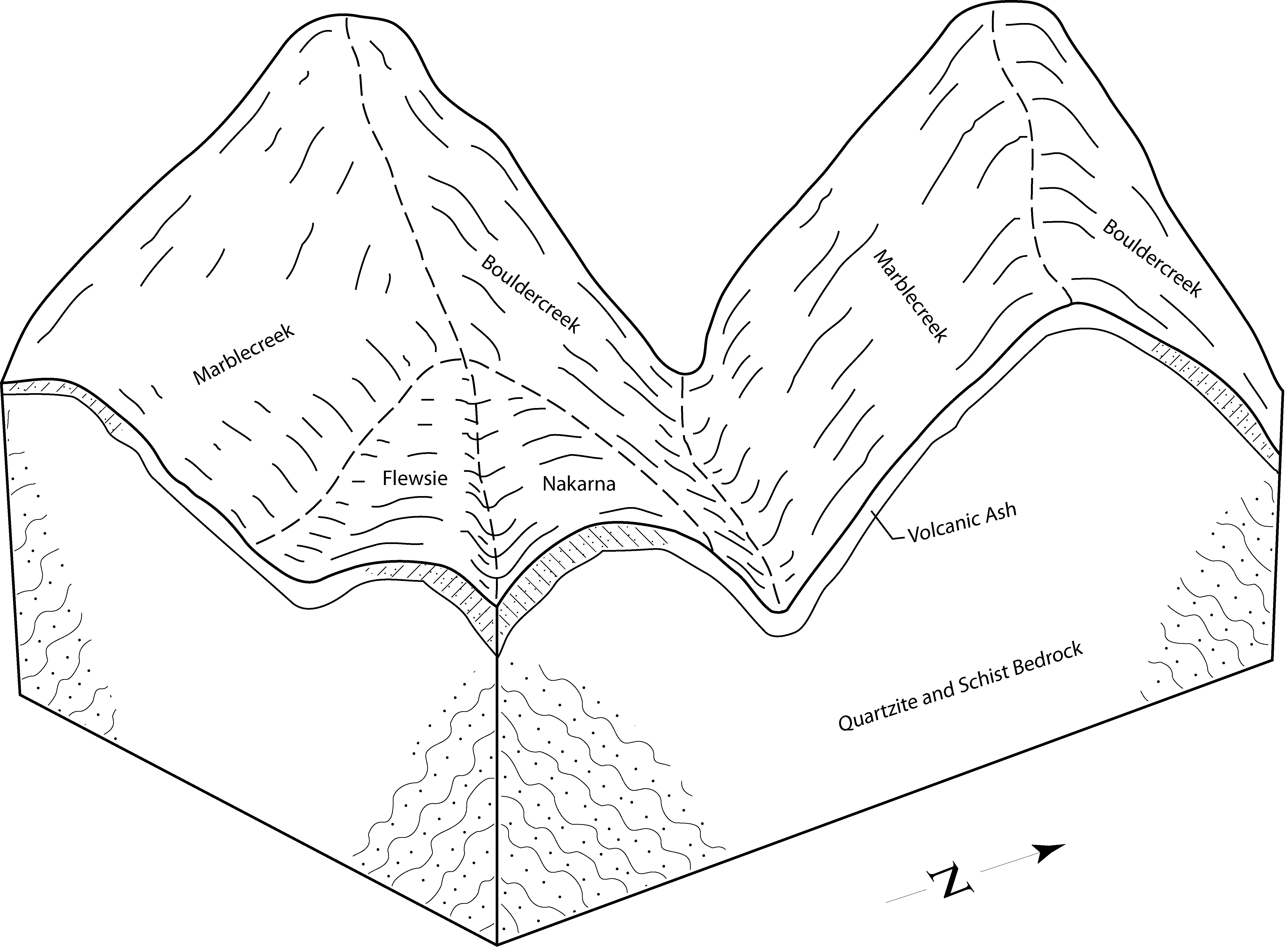
| Bouldercreek-Marblecreek association, 35 to 65 percent slopes | Bm1j | 4452 | 2501165 | 54lr | id057 | 2013 | 1:24000 |
Bouldercreek-Flewsie-Secunda complex, 35 to 75 percent slopes | Sf4 | 3843 | 814019 | wb1p | id057 | 2013 | 1:24000 |
Flewsie-Bouldercreek complex, 30 to 55 percent slopes | Fb4 | 3442 | 657112 | q1s5 | id057 | 2013 | 1:24000 |
Jacot, warm-Bouldercreek-Jacot, warm, moist complex, 35 to 60 percent slopes | Bj1 | 1400 | 644261 | pmdm | id057 | 2013 | 1:24000 |
Bouldercreek ashy silt loam, 35 to 65 percent slopes | Bu3j | 1183 | 2501173 | 2w5t8 | id057 | 2013 | 1:24000 |
Jacot-Bouldercreek complex, 35 to 65 percent slopes | Bj2 | 974 | 644262 | pmdn | id057 | 2013 | 1:24000 |
Noil-Bouldercreek-Rock outcrop complex, 45 to 85 percent slopes | Be1j | 266 | 2501163 | v11l | id057 | 2013 | 1:24000 |
Bouldercreek-Wietas complex, 8 to 25 percent slopes | Jw1 | 170 | 1689267 | 1tpth | id057 | 2013 | 1:24000 |
Bouldercreek-Ahrs families, complex, weakly weathered metasedimentary belt geology, mountain slopes, south aspects | 2lg9m | 98 | 2850873 | 2lg9m | id604 | 1981 | 1:24000 |
Bouldercreek family, weakly weathered metasedimentary belt geology, mountain slopes, north aspects | 2lg9g | 47 | 2850870 | 2lg9g | id604 | 1981 | 1:24000 |
Bouldercreek family, weakly weathered metasedimentary belt geology, mountain ridges and upper slopes, north aspects | 2lgbd | 30 | 2850879 | 2lgbd | id604 | 1981 | 1:24000 |
Bouldercreek-Humic Udivitrands families, complex, weakly weathered belt geology, lower sideslopes toeslopes and stream bottoms of incised drainages along slopes, north aspects | 2lg9h | 5 | 2850871 | 2lg9h | id604 | 1981 | 1:24000 |
Bouldercreek-Humic Udivitrands families, complex, weakly weathered belt geology, lower sideslopes toeslopes and stream bottoms of incised drainages along slopes, south aspects | 2lg9j | 2 | 2850872 | 2lg9j | id604 | 1981 | 1:24000 |
Bouldercreek ashy silt loam, 30 to 60 percent slopes | 5111 | 4012 | 2662906 | 2wfm | id606 | 1976 | 1:24000 |
Bouldercreek, dry-Kellerbutte complex, 30 to 60 percent slopes | 5113 | 826 | 2662907 | 2wfr | id606 | 1976 | 1:24000 |
Bouldercreek-Rock outcrop-Bouldercreek, dry complex, 30 to 70 percent slopes | 5114 | 746 | 2662908 | 2wfs | id606 | 1976 | 1:24000 |
Bouldercreek ashy silt loam, dry, 15 to 30 percent slopes | 5112 | 377 | 2662905 | 2wf0 | id606 | 1976 | 1:24000 |
Bouldercreek ashy silt loam, 15 to 30 percent slopes | 5110 | 142 | 2662904 | 2wfq | id606 | 1976 | 1:24000 |
Hugus-Bouldercreek-Humic Udivitrands families, complex, moderately weathered belts, lower sideslopes toeslopes and stream bottoms of incised drainages, north aspects | 2lg9c | 13 | 2850888 | 2lg9c | id606 | 1976 | 1:24000 |
Bouldercreek ashy silt loam, 35 to 65 percent slopes | 779 | 10 | 2663006 | 2w5t8 | id606 | 1976 | 1:24000 |
Bouldercreek family, weakly weathered metasedimentary belt geology, mountain ridges and upper slopes, north aspects | 2lgbd | 3 | 2850893 | 2lgbd | id606 | 1976 | 1:24000 |
Bouldercreek-Marblecreek association, 35 to 65 percent slopes | 15 | 44710 | 153380 | 54lr | id608 | 1994 | 1:24000 |
Bouldercreek ashy silt loam, 35 to 65 percent slopes | 12 | 42124 | 153349 | 2w5t8 | id608 | 1994 | 1:24000 |
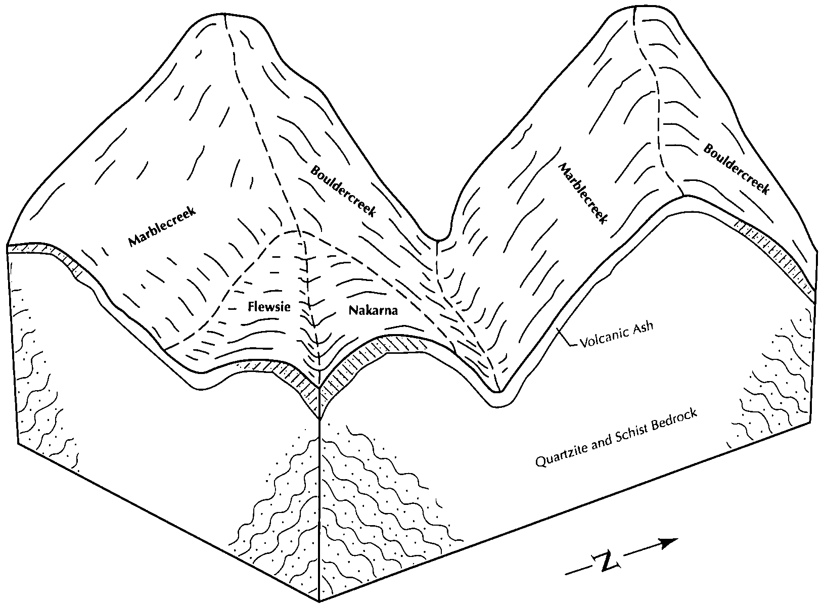
Bouldercreek-Marblecreek association, 15 to 35 percent slopes | 14 | 3269 | 153370 | 54lf | id608 | 1994 | 1:24000 |
Bouldercreek ashy loam, high precipitation, 35 to 75 percent slopes | 13 | 2779 | 153360 | 54l3 | id608 | 1994 | 1:24000 |
Bouldercreek, high precipitation-Marblecreek association, 25 to 65 percent slopes | 16 | 2442 | 153390 | 54m2 | id608 | 1994 | 1:24000 |
Bouldercreek family, weakly weathered metasedimentary belt geology, mountain slopes, north aspects | 2lg9g | 83 | 2936792 | 2lg9g | id608 | 1994 | 1:24000 |
Bouldercreek-Ahrs families, complex, weakly weathered metasedimentary belt geology, mountain slopes, south aspects | 2lg9m | 79 | 2936775 | 2lg9m | id608 | 1994 | 1:24000 |
Bouldercreek-Humic Udivitrands families, complex, weakly weathered metasedimentary belt geology, dissected stream breaklands, north aspects | 2lgb3 | 73 | 2936786 | 2lgb3 | id608 | 1994 | 1:24000 |
Hugus-Bouldercreek-Humic Udivitrands families, complex, moderately weathered belts, lower sideslopes toeslopes and stream bottoms of incised drainages, north aspects | 2lg9c | 57 | 2936797 | 2lg9c | id608 | 1994 | 1:24000 |
Bouldercreek family, weakly weathered granitic geology, mountain slopes, north aspects | 2lgq6 | 49 | 2936795 | 2lgq6 | id608 | 1994 | 1:24000 |
Bouldercreek-Humic Udivitrands families, complex, weakly weathered belt geology, lower sideslopes toeslopes and stream bottoms of incised drainages along slopes, south aspects | 2lg9j | 24 | 2936782 | 2lg9j | id608 | 1994 | 1:24000 |
Bouldercreek family, weakly weathered metasedimentary belt geology, mountain ridges and upper slopes, north aspects | 2lgbd | 16 | 2936791 | 2lgbd | id608 | 1994 | 1:24000 |
Bouldercreek-Hubub-Hugus families, complex, moderately weathered belt rock, dissected lower mountain slopes toeslopes and stream bottoms, south aspects | 2lg4d | 8 | 2936789 | 2lg4d | id608 | 1994 | 1:24000 |
Micapeak-Bouldercreek families, complex, weakly weathered granitic geology, dissected stream breaklands, south aspects | 2lgqg | 8 | 2936780 | 2lgqg | id608 | 1994 | 1:24000 |
Bouldercreek-Humic Udivitrands families, complex, weakly weathered belt geology, lower sideslopes toeslopes and stream bottoms of incised drainages along slopes, north aspects | 2lg9h | 7 | 2936800 | 2lg9h | id608 | 1994 | 1:24000 |
Hugus-Bouldercreek families, complex, weak to moderately weathered belt rock, dissected mountain slopes, south aspects | 2lg4c | 1 | 2936785 | 2lg4c | id608 | 1994 | 1:24000 |
Bouldercreek-Brodeer complex, 35 to 70 percent slopes | 24 | 7510 | 775587 | v11y | id612 | 2003 | 1:24000 |
Bouldercreek, moist-Brodeer complex, 35 to 70 percent slopes | 23 | 6024 | 775585 | v11w | id612 | 2003 | 1:24000 |
Bouldercreek ashy silt loam, 35 to 75 percent slopes | 22 | 5149 | 775579 | v11p | id612 | 2003 | 1:24000 |
Noil-Bouldercreek-Rock outcrop complex, 45 to 85 percent slopes | 178 | 4322 | 775576 | v11l | id612 | 2003 | 1:24000 |
Bouldercreek-Vassar complex, 35 to 75 percent slopes | 25 | 4120 | 775584 | v11v | id612 | 2003 | 1:24000 |
Bouldercreek-Rettig complex, 45 to 90 percent slopes | 27 | 3645 | 775583 | v11t | id612 | 2003 | 1:24000 |
Bouldercreek, high precipitation-Marblecreek association, 25 to 65 percent slopes | 26 | 2309 | 775580 | 54m2 | id612 | 2003 | 1:24000 |
Brodeer-Bouldercreek complex, 15 to 40 percent slopes | 37 | 1687 | 777392 | v2y5 | id612 | 2003 | 1:24000 |
Bouldercreek ashy silt loam, 35 to 65 percent slopes | 21 | 1504 | 775588 | 2w5t8 | id612 | 2003 | 1:24000 |
Bouldercreek ashy loam, 15 to 35 percent slopes | 20 | 1404 | 775586 | v11x | id612 | 2003 | 1:24000 |
Bouldercreek ashy silt loam, warm, 35 to 65 percent slopes | 777 | 460 | 1390155 | 1hnkq | id620 | 2013 | 1:24000 |
Bouldercreek ashy silt loam, 35 to 65 percent slopes | 779 | 167 | 1390157 | 2w5t8 | id620 | 2013 | 1:24000 |
Bouldercreek family, weakly weathered metasedimentary belt geology, mountain slopes, north aspects | 466 | 155844 | 2397027 | 2lg9g | id670 | | 1:24000 |
Bouldercreek-Ahrs families, complex, weakly weathered metasedimentary belt geology, mountain slopes, south aspects | 470 | 138643 | 2397032 | 2lg9m | id670 | | 1:24000 |
Bouldercreek-Humic Udivitrands families, complex, weakly weathered metasedimentary belt geology, dissected stream breaklands, north aspects | 480 | 73931 | 2397047 | 2lgb3 | id670 | | 1:24000 |
Bouldercreek-Humic Udivitrands families, complex, weakly weathered belt geology, lower sideslopes toeslopes and stream bottoms of incised drainages along slopes, north aspects | 467 | 60425 | 2397028 | 2lg9h | id670 | | 1:24000 |
Bouldercreek-Humic Udivitrands families, complex, weakly weathered belt geology, lower sideslopes toeslopes and stream bottoms of incised drainages along slopes, south aspects | 468 | 44639 | 2397029 | 2lg9j | id670 | | 1:24000 |
Hugus-Bouldercreek-Humic Udivitrands families, complex, moderately weathered belts, lower sideslopes toeslopes and stream bottoms of incised drainages, north aspects | 463 | 30316 | 2397024 | 2lg9c | id670 | | 1:24000 |
Bouldercreek family, weakly weathered metasedimentary belt geology, mountain ridges and upper slopes, north aspects | 491 | 26482 | 2397056 | 2lgbd | id670 | | 1:24000 |
Bouldercreek family, weakly weathered granitic geology, mountain slopes, north aspects | 562 | 17412 | 2397422 | 2lgq6 | id670 | | 1:24000 |
Bouldercreek-Goatrock families-Rock outrcrop complex, steep breaklands with avalanche chutes, weakly weathered belts, timber-brush-fern glade mosaic, north aspects | 415 | 13756 | 2396861 | 2lg43 | id670 | | 1:24000 |
Hugus-Bouldercreek families, complex, weak to moderately weathered belt rock, dissected mountain slopes, south aspects | 446 | 4723 | 2396869 | 2lg4c | id670 | | 1:24000 |
Bouldercreek family, weakly weathered mica schist geology, mountain slopes, north aspects | 766 | 3356 | 2397474 | 2lgrw | id670 | | 1:24000 |
Bouldercreek-Hugus-Humic Udivitrands families, complex, moderately weathered belt rock, dissected breaklands, north aspects | 481 | 3103 | 2397048 | 2lgb4 | id670 | | 1:24000 |
Bouldercreek-Humic Udivitrands families, complex, weakly weathered mica schist, lower sideslopes toeslopes and stream bottoms of incised drainages along slopes, north aspects | 767 | 2926 | 2397475 | 2lgrx | id670 | | 1:24000 |
Hubub-Bouldercreek-Hugus families, complex, weathered belt geology, dissected rolling uplands, north aspects | 461 | 2374 | 2397019 | 2lg96 | id670 | | 1:24000 |
Bouldercreek-Hubub-Hugus families, complex, moderately weathered belt rock, dissected lower mountain slopes toeslopes and stream bottoms, south aspects | 447 | 2325 | 2396870 | 2lg4d | id670 | | 1:24000 |
Bouldercreek-Humic Udivitrands families-Rock outcrop complex, weakly weathered metasedimentary belt geology, dissected stream breaklands, north aspects | 489 | 2266 | 2397054 | 2lgbb | id670 | | 1:24000 |
Hubub-Bouldercreek families, complex, weathered belt geology, dissected rolling uplands, south aspects | 457 | 1894 | 2397013 | 2lg90 | id670 | | 1:24000 |
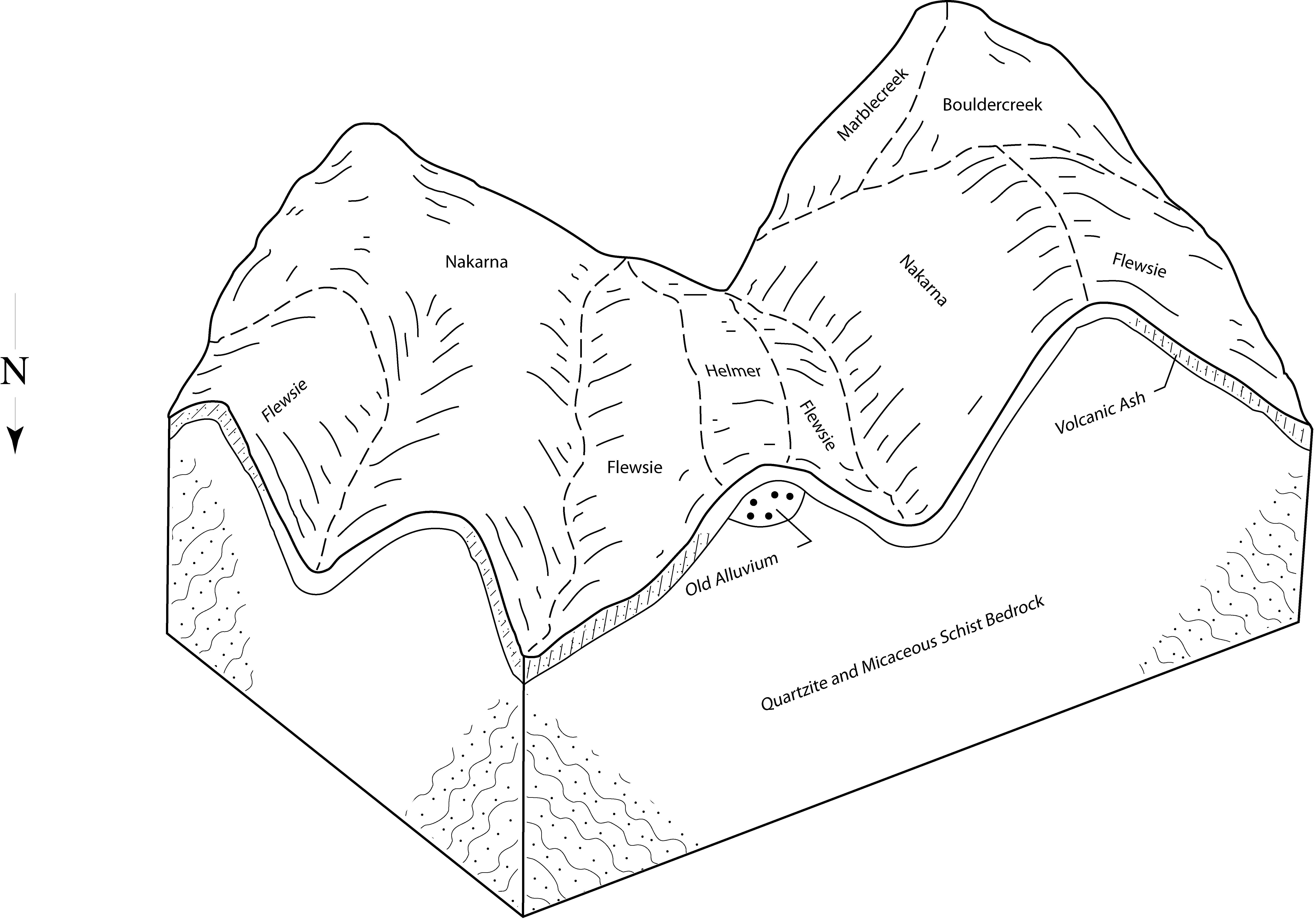
Bouldercreek-Hubub families, complex, alluvial fans | 133 | 1828 | 2396714 | 2lfzc | id670 | | 1:24000 |
Bouldercreek family, weakly weathered mica schist geology, stream breaks, north aspects | 777 | 1648 | 2397480 | 2lgs2 | id670 | | 1:24000 |
Bouldercreek-Hugus families, complex, stream terraces, toe slopes, and alluvial fans | 131 | 1428 | 2396709 | 2lfz6 | id670 | | 1:24000 |
Bouldercreek famiily, weakly weathered belt rock, dissected mountain slopes, south aspects | 469 | 948 | 2397030 | 2lg9k | id670 | | 1:24000 |
Bouldercreek-Humic Udivitrands families, complex, weakly weathered schists, lower sideslopes toeslopes and stream bottoms of incised drainages along slopes, south aspects | 768 | 798 | 2397476 | 2lgry | id670 | | 1:24000 |
Bouldercreek ashy silt loam, 35 to 65 percent slopes | 2w5t8 | 684 | 2850958 | 2w5t8 | id670 | | 1:24000 |
Brodeer-Bouldercreek families, complex, belts, lower sideslopes toeslopes and stream bottoms of incised drainages in rolling uplands, south aspects | 455 | 623 | 2397010 | 2lg8x | id670 | | 1:24000 |
Humic Udivitrands-Bouldercreek-Hugus families, complex, weathered, rotational failures | 198 | 449 | 2396739 | 2lg05 | id670 | | 1:24000 |
Bouldercreek-Marblecreek association, 35 to 65 percent slopes | 54lr | 336 | 2850961 | 54lr | id670 | | 1:24000 |
Bouldercreek-Sunroad-Blackprince families, complex, weakly to moderately weathered granitic geology, mountain ridges and upper slopes | 590 | 269 | 2397433 | 2lgqk | id670 | | 1:24000 |
Bouldercreek-Marblecreek association, 15 to 35 percent slopes | 54lf | 158 | 2850960 | 54lf | id670 | | 1:24000 |
Bouldercreek family, weakly weathered granitic geology, stream breaklands, north aspects | 577 | 134 | 2397429 | 2lgqf | id670 | | 1:24000 |
Noil-Bouldercreek-Rock outcrop complex, 45 to 85 percent slopes | v11l | 113 | 2936847 | v11l | id670 | | 1:24000 |
Bouldercreek ashy loam, high precipitation, 35 to 75 percent slopes | 54l3 | 82 | 2850959 | 54l3 | id670 | | 1:24000 |
Micapeak-Bouldercreek families, complex, weakly weathered granitic geology, dissected stream breaklands, south aspects | 579 | 77 | 2397430 | 2lgqg | id670 | | 1:24000 |
Bouldercreek family, weakly weathered granitic geology, dissected rolling uplands, north aspects | 567 | 52 | 2397425 | 2lgq9 | id670 | | 1:24000 |
Bouldercreek family, weakly weathered granitic geology, lower sideslopes toeslopes and stream bottoms of incised drainages within mountain slopes, south aspects | 568 | 50 | 2397426 | 2lgqb | id670 | | 1:24000 |
Bouldercreek, high precipitation-Marblecreek association, 25 to 65 percent slopes | 54m2 | 8 | 2850962 | 54m2 | id670 | | 1:24000 |
Bouldercreek ashy silt loam, 30 to 60 percent slopes | 5111 | 4066 | 85951 | 2wfm | wa063 | 2012 | 1:24000 |
Bouldercreek, dry-Kellerbutte complex, 30 to 60 percent slopes | 5113 | 2105 | 85955 | 2wfr | wa063 | 2012 | 1:24000 |
Bouldercreek ashy silt loam, moist, 3 to 15 percent slopes | 5060 | 1447 | 85915 | 2wdg | wa063 | 2012 | 1:24000 |
Bouldercreek-Rock outcrop-Bouldercreek, dry complex, 30 to 70 percent slopes | 5114 | 1155 | 85956 | 2wfs | wa063 | 2012 | 1:24000 |
Bouldercreek ashy silt loam, dry, 15 to 30 percent slopes | 5112 | 862 | 85932 | 2wf0 | wa063 | 2012 | 1:24000 |
Bouldercreek ashy silt loam, 15 to 30 percent slopes | 5110 | 406 | 85954 | 2wfq | wa063 | 2012 | 1:24000 |
Bouldercreek family, weakly weathered metasedimentary belt geology, mountain slopes, north aspects | 2lg9g | 835 | 2936817 | 2lg9g | wa651 | 1981 | 1:24000 |
Bouldercreek-Ahrs families, complex, weakly weathered metasedimentary belt geology, mountain slopes, south aspects | 2lg9m | 512 | 2850902 | 2lg9m | wa651 | 1981 | 1:24000 |
Bouldercreek family, weakly weathered granitic geology, mountain slopes, north aspects | 2lgq6 | 488 | 2850924 | 2lgq6 | wa651 | 1981 | 1:24000 |
Bouldercreek-Humic Udivitrands families, complex, weakly weathered belt geology, lower sideslopes toeslopes and stream bottoms of incised drainages along slopes, north aspects | 2lg9h | 322 | 2850927 | 2lg9h | wa651 | 1981 | 1:24000 |
Bouldercreek-Humic Udivitrands families, complex, weakly weathered belt geology, lower sideslopes toeslopes and stream bottoms of incised drainages along slopes, south aspects | 2lg9j | 180 | 2850908 | 2lg9j | wa651 | 1981 | 1:24000 |
Bouldercreek ashy silt loam, moist, 3 to 15 percent slopes | 5060 | 38 | 2651247 | 2wdg | wa651 | 1981 | 1:24000 |
Bouldercreek-Humic Udivitrands families, complex, weakly weathered metasedimentary belt geology, dissected stream breaklands, north aspects | 2lgb3 | 18 | 2850916 | 2lgb3 | wa651 | 1981 | 1:24000 |


